
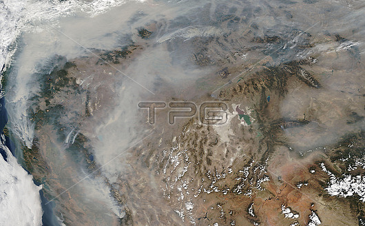
Satellite image of smoke from wildfires along the pacific coast of the USA. Since mid-August millions of acres have burned on the Pacific coast, destroying thousands of homes and killing dozens of people. Data obtained by the Moderate Resolution Imaging Spectroradiometer (MODIS) on NASA??? Terra satellite on 15th September 2020.
| px | px | dpi | = | cm | x | cm | = | MB |
Details
Creative#:
TOP25842174
Source:
達志影像
Authorization Type:
RM
Release Information:
須由TPG 完整授權
Model Release:
N/A
Property Release:
N/A
Right to Privacy:
No
Same folder images:
15september20202000s21stcenturyatmosphereatmosphericbushfirecaliforniaclimatechangeclimatologicalclimatologycoastenvironmentenvironmentalfirefiresfromspaceglobalwarmingnaturaldisasterno-onenobodynorthamericanorthamericanoregonpacificpacificcoastpollutionsatelliteimagesmokeunitedstatesusawashingtonstatewildfirewildfiremoderateresolutionimagingspectroradiometermodisterra
152000s202021stamericaamericanatmosphereatmosphericbushfirecaliforniacenturychangeclimateclimatologicalclimatologycoastcoastdisasterenvironmentenvironmentalfirefirefiresfromglobalimageimagingmoderatemodisnaturalno-onenobodynorthnorthoregonpacificpacificpollutionresolutionsatelliteseptembersmokespacespectroradiometerstatestatesterraunitedusawarmingwashingtonwildwildfire
 Loading