
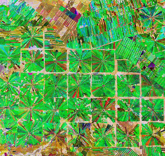
Deforestation in Bolivia. Composite satellite image of an area in the Santa Cruz Department of Bolivia, showing where part of the tropical dry forest has been cleared for agricultural use. Each patterned field is approximately 20 sq km and each side is around 2.5 km long. Since the 1980s this region has been rapidly deforested due to the relatively flat lowlands and abundant rainfall that make it suitable for farming. Imaged by the Copernicus Sentinel 2 satellite on 8th April 2019 (red), 22nd June 2019 (green) and 5th September 2019 (blue).
| px | px | dpi | = | cm | x | cm | = | MB |
Details
Creative#:
TOP25529415
Source:
達志影像
Authorization Type:
RM
Release Information:
須由TPG 完整授權
Model Release:
N/A
Property Release:
N/A
Right to Privacy:
No
Same folder images:
21stcentury2019nobodyno-onesentinel2sentinel-2esaeuropeanspaceagencypreparingpreparationweatherclimatologyclimatologicalclimatechangeglobalwarmingenvironmentenvironmentalsciencemonitoringresearchgeographygeographicaldeforestationboliviasouthamericasouthamericanboliviansantacruzfarmingagricultureagriculturalfarmfarmsdeforestedlanduseclearedclearingtropicaltropictropicsfieldfieldslowlandlowlandssatelliteimagefromabovelookingdownlatinamericafromspace
2201921staboveagencyagriculturalagricultureamericaamericaamericanboliviaboliviancenturychangeclearedclearingclimateclimatologicalclimatologycruzdeforestationdeforesteddownenvironmentenvironmentalesaeuropeanfarmfarmingfarmsfieldfieldsfromfromgeographicalgeographyglobalimagelandlatinlookinglowlandlowlandsmonitoringno-onenobodypreparationpreparingresearchsantasatellitesciencesentinelsentinel-2southsouthspacespacetropictropicaltropicsusewarmingweather
 Loading