
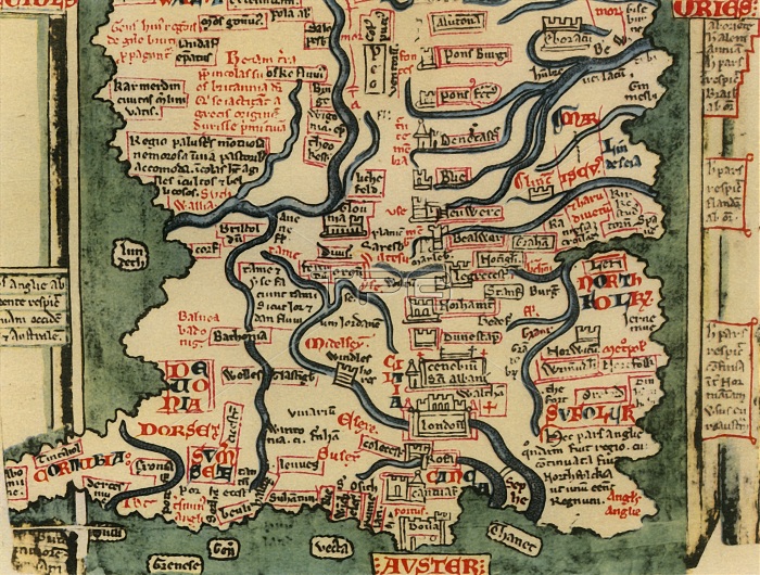
'Matthew Paris's Map of Great Britain, c.1250', (1944). Creator: Matthew Paris.
| px | px | dpi | = | cm | x | cm | = | MB |
Details
Creative#:
TOP25464497
Source:
達志影像
Authorization Type:
RM
Release Information:
須由TPG 完整授權
Model Release:
No
Property Release:
No
Right to Privacy:
No
Same folder images:
weatherriverriversseacoastEnglandwindcoastalWalescountrycoastlineBritishgeographyEnglishcolordesignwindymedievalCornwalltextlocationcenturyBritainchannelDorset1940smanuscriptletteringEnglishChannelFortiesEastAngliaColourgraphicdesignmediaevalMiddleAges20thcenturyThirteenthCentury13thcenturyhistoryThePrintCollectordecadegeographicalfeatureTGNWestCountrymapmanuscriptWilliamCollinsEdwardMatthewParisParisMatthewWilliamCollinssocialhistoryBritaininPicturesWilliamCollins&SonsEdwardLynamLynam
&13th1940s20thAgesAngliaBritainBritainBritishCenturyChannelCollectorCollinsCollinsCollinsColourCornwallCountryDorsetEastEdwardEdwardEnglandEnglishEnglishFortiesLynamLynamMatthewMatthewMiddleParisParisPicturesPrintSonsTGNTheThirteenthWalesWestWilliamWilliamWilliamcenturycenturycenturychannelcoastcoastalcoastlinecolorcountrydecadedesigndesignfeaturegeographicalgeographygraphichistoryhistoryinletteringlocationmanuscriptmanuscriptmapmediaevalmedievalriverriversseasocialtextweatherwindwindy
 Loading