
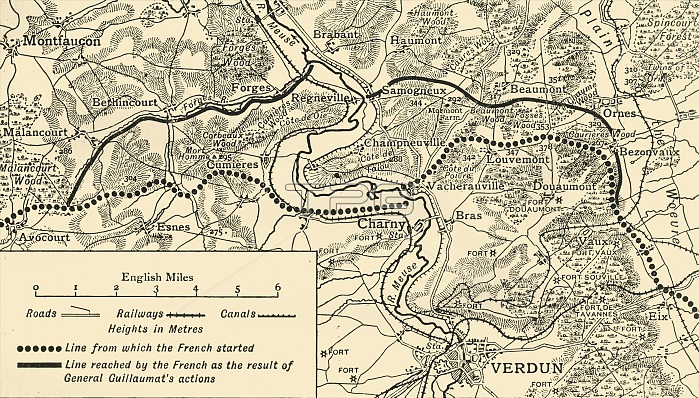
'Map illustrating the Operations at Verdun', First World War, August-November, 1917, (c1920). Map of the area around the town of Verdun in northern France, showing 'Line from which the French started', and 'Line reached by the French as the result of General [Adolphe] Guillaumat's actions'. From "The Great World War: A History", Volume VII, edited by Frank A Mumby. [The Gresham Publishing Company Ltd, London, c1920]
| px | px | dpi | = | cm | x | cm | = | MB |
Details
Creative#:
TOP25460477
Source:
達志影像
Authorization Type:
RM
Release Information:
須由TPG 完整授權
Model Release:
No
Property Release:
No
Right to Privacy:
No
Same folder images:
linescountryFrenchFrancebookwarfrontlocationcenturyfirstworldwarpositionconceptLorrainepositionsWorldWarIWWIbattlefieldB/WWorldWarOnefrontline1910s20thcenturyMeuseThePrintCollector1stWorldWarTGNVerdunWesternFrontWW1mapfrontlineUnknownKeystoneArchivestheatreofwarTheGreatWorldWar:AHistoryFrankArthurMumbyMumbyFrankArthurGreshamPublishingCompanyGreshamPublishingCoLtdFrankAMumbyFrankA.MumbyFrankA.FrankAAdolpheMarieLouisAdolpheGuillaumatAdolpheGuillaumatGeneralGuillaum
1910s1st20thAAAA.A.AdolpheAdolpheAdolpheArchivesArthurArthurB/WCoCollectorCompanyFranceFrankFrankFrankFrankFrankFrankFrenchFrontGeneralGreatGreshamGreshamGuillaumGuillaumatGuillaumatHistoryIKeystoneLorraineLouisLtdMarieMeuseMumbyMumbyMumbyMumbyOnePrintPublishingPublishingTGNTheTheUnknownVerdunWW1WWIWarWarWarWar:WesternWorldWorldWorldWorldbattlefieldbookcenturycenturyconceptcountryfirstfrontfrontfrontlinelinelineslocationmapofpositionpositionstheatrewarwarwarworld
 Loading