
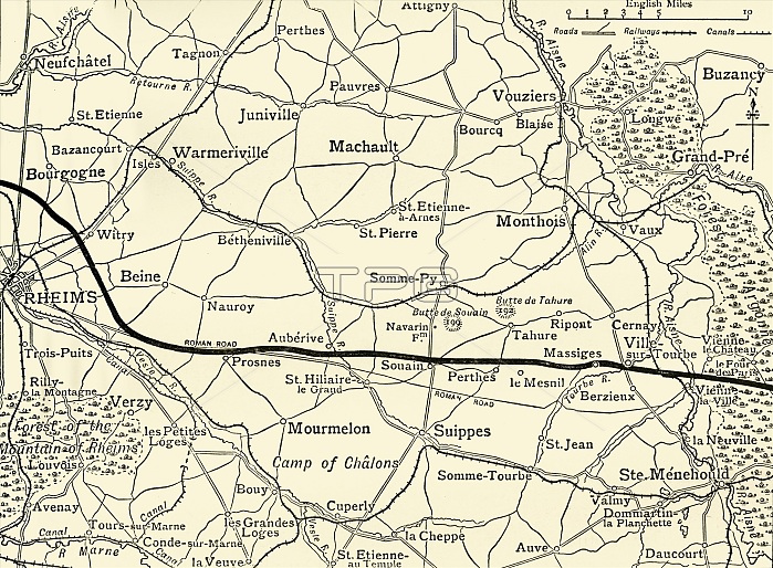
'The Battle-fields of Champagne', First World War, 1915, (c1920). '...map showing approximately the French line between Rheims and the Argonne Forest [in northern France] before the great offensive of September, 1915'. From "The Great World War: A History", Volume V, edited by Frank A Mumby. [The Gresham Publishing Company Ltd, London, c1920]
| px | px | dpi | = | cm | x | cm | = | MB |
Details
Creative#:
TOP25460353
Source:
達志影像
Authorization Type:
RM
Release Information:
須由TPG 完整授權
Model Release:
No
Property Release:
No
Right to Privacy:
No
Same folder images:
forestcountryFrenchFrancebookterritorialwarfrontlocationReimscenturyfirstworldwarTERRITORYconceptWorldWarIWWIbattlefieldB/WWorldWarOnefrontline1910s20thcenturyChampagne-ArdenneThePrintCollector1stWorldWarArgonneForestRheimsTGNWesternFrontWW1mapfrontlineUnknownKeystoneArchivesForestofArgonnetheatreofwarTheGreatWorldWar:AHistoryFrankArthurMumbyMumbyFrankArthurGreshamPublishingCompanyGreshamPublishingCoLtdFrankAMumbyFrankA.MumbyFrankA.FrankA
1910s1st20thAAAA.A.ArchivesArgonneArgonneArthurArthurB/WChampagne-ArdenneCoCollectorCompanyForestForestFranceFrankFrankFrankFrankFrankFrankFrenchFrontGreatGreshamGreshamHistoryIKeystoneLtdMumbyMumbyMumbyMumbyOnePrintPublishingPublishingReimsRheimsTERRITORYTGNTheTheUnknownWW1WWIWarWarWarWar:WesternWorldWorldWorldWorldbattlefieldbookcenturycenturyconceptcountryfirstforestfrontfrontfrontlinelinelocationmapofofterritorialtheatrewarwarwarworld
 Loading