
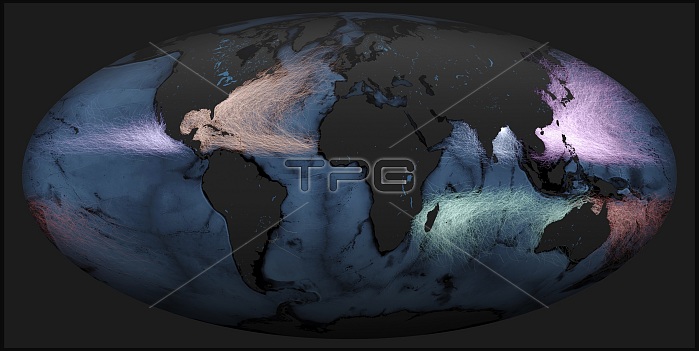
World's storms between 1842 and 2017. The storm tracks are colour-coded for the ocean basins they form in. Brighter areas indicate where a large number of storm tracks have overlapped. There are seven major storm areas: Eastern Pacific (pale purple, left), North Atlantic (pale orange), South Pacific (red), South Atlantic (pale yellow, lower centre left), South Indian (turquoise), Western Pacific (bright pink), and North Indian (blue). The North Indian basin has relatively few storms, but a surge of strong storms here occurred in 2019. This is thought to be due to a climate phenomenon known as the Indian Ocean Dipole (IOD). This image uses storm track data from NOAA's IBTrACS (International Best Track Archive for Climate Stewardship) database.
| px | px | dpi | = | cm | x | cm | = | MB |
Details
Creative#:
TOP25373265
Source:
達志影像
Authorization Type:
RM
Release Information:
須由TPG 完整授權
Model Release:
N/A
Property Release:
N/A
Right to Privacy:
No
Same folder images:
 Loading