
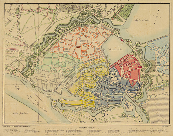
Hamburg (Germany);- PLAN VON HAMBURG; den Wallanlagen und den n鋍hsten Umgebungen der Stadt. -(Plan of Hamburg; the ramparts and the nearest surroundings of the city).Colour lithograph by Otto Speckter (1807-1871).41 x 56 cm.Hamburg; 1835 (F.H. Nestler & Melle).Hamburg; State and University Library.
| px | px | dpi | = | cm | x | cm | = | MB |
Details
Creative#:
TOP24888923
Source:
達志影像
Authorization Type:
RM
Release Information:
須由TPG 完整授權
Model Release:
No
Property Release:
No
Right to Privacy:
No
Same folder images:
19THCENTURY2NDMILLENNIUMA.D.ALSTERArtAUSSENALSTERBINNENALSTERCDCHROMOLITHOGRAPHYCHROMOLITHOGRAPHCITYTOWNCITYCENTRECITYCENTERCITYWALLELBE(RIVER)EUROPEFRIEDRICHHERMANNNESTLERGEOGRAPHYGERMANARTGERMANYGRAPHICARTGRAPHICARTSHAMBURGHamburgStateandUniversityLibraryHEILIGENGEISTFIELDJULIUSFRIEDRICHWILHELMMELLELANDSCAPEFORMATLITHOGRAPHMAPMAPMAKINGNORTHERNGERMANYOTTOSPECKTERPlacesandTravelPORTHARBORHARBOURPRINTEDGRAPHICSRIVERTIDETOPOGRAPHYTOWNMAPCITYMAPURBANISM
(RIVER)19TH2NDA.D.ALSTERARTARTARTSAUSSENALSTERArtBINNENALSTERCDCENTERCENTRECENTURYCHROMOLITHOGRAPHCHROMOLITHOGRAPHYCITYCITYCITYCITYCITYELBEEUROPEFIELDFORMATFRIEDRICHFRIEDRICHGEOGRAPHYGERMANGERMANYGERMANYGRAPHICGRAPHICGRAPHICSHAMBURGHARBORHARBOURHEILIGENGEISTHERMANNHamburgJULIUSLANDSCAPELITHOGRAPHLibraryMAKINGMAPMAPMAPMAPMELLEMILLENNIUMNESTLERNORTHERNOTTOPORTPRINTEDPlacesRIVERSPECKTERStateTIDETOPOGRAPHYTOWNTOWNTravelURBANISMUniversityWALLWILHELMandand
 Loading