
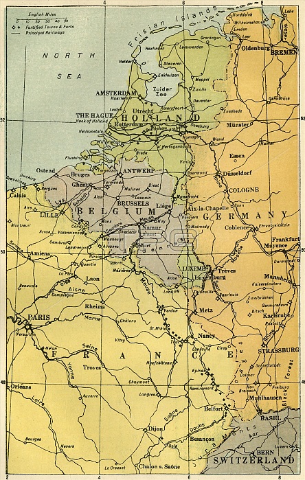
'Map of the Belgian Frontier with Forts', 1919. Map showing Belgium, Holland and parts of Germany and France during the First World War, 1914-1919. Fortified towns and principal railways are indicated. From "The History of the Great European War: its causes and effects", Vol. I, by W. Stanley Macbean Knight. [Caxton Pulishing Company, Limited, London, 1919]
| px | px | dpi | = | cm | x | cm | = | MB |
Details
Creative#:
TOP24719203
Source:
達志影像
Authorization Type:
RM
Release Information:
須由TPG 完整授權
Model Release:
No
Property Release:
No
Right to Privacy:
No
Same folder images:
transporttransportationGermanyseacoastbuildingfortfortsFranceLuxembourggeographyHollandNetherlandsBelgiumrailwaycolorfortificationwarcenturyfirstworldwarconceptNorthSeafrontierColourWorldWarIWWIWorldWarOne1910s20thcenturyThePrintCollector1stWorldWargeographicalfeatureTGNWW1mapUnknownKnightCaxtonPublishingCompanyWilliamStanleyMacbeanKnightWilliamStanleyMacbeanW.StanleyMacbeanKnightWStanleyMacbeanKnightW.StanleyMacbeanWStanleyMacbeanW.S.M.W.S.M.KnightCaxtonPulishingCompanyLim
1910s1st20thBelgiumCaxtonCaxtonCollectorColourCompanyCompanyFranceGermanyHollandIKnightKnightKnightKnightKnightLimLuxembourgM.M.MacbeanMacbeanMacbeanMacbeanMacbeanMacbeanNetherlandsNorthOnePrintPublishingPulishingS.S.SeaStanleyStanleyStanleyStanleyStanleyStanleyTGNTheUnknownWWW.W.W.W.WW1WWIWarWarWarWilliamWilliamWorldWorldWorldbuildingcenturycenturycoastcolorconceptfeaturefirstfortfortificationfortsfrontiergeographicalgeographymaprailwayseatransporttransportationwarwarworld
 Loading