
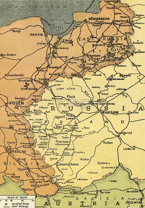
'The Eastern Frontier', 1919. Map showing parts of Germany, Prussia, Russia and Austria during the First World War, 1914-1919, with fortified towns and main railway lines indicated. From "The History of the Great European War: its causes and effects", Vol. III, by W. Stanley Macbean Knight. [Caxton Pulishing Company, Limited, London, 1919]
| px | px | dpi | = | cm | x | cm | = | MB |
Details
Creative#:
TOP24719037
Source:
達志影像
Authorization Type:
RM
Release Information:
須由TPG 完整授權
Model Release:
No
Property Release:
No
Right to Privacy:
No
Same folder images:
GermanyseacountryAustriageographycolorPolandAustrianwarfrontlocationcenturyempireRussiafirstworldwarconceptfrontierColourWorldWarIWWIWorldWarOne1910s20thcenturyBalticSeaThePrintCollector1stWorldWarAustro-HungarianeasternfrontgeographicalfeaturePrussiaWW1mapAustria-HungaryKnightAustro-HungarianEmpireCaxtonPublishingCompanyWilliamStanleyMacbeanKnightWilliamStanleyMacbeanW.StanleyMacbeanKnightWStanleyMacbeanKnightW.StanleyMacbeanWStanleyMacbeanW.S.M.W.S.M.KnightCaxtonPulishingCompanyLimtheatreofwarLondonGeographicalInstitute
1910s1st20thAustriaAustria-HungaryAustrianAustro-HungarianAustro-HungarianBalticCaxtonCaxtonCollectorColourCompanyCompanyEmpireGeographicalGermanyIInstituteKnightKnightKnightKnightKnightLimLondonM.M.MacbeanMacbeanMacbeanMacbeanMacbeanMacbeanOnePolandPrintPrussiaPublishingPulishingRussiaS.S.SeaStanleyStanleyStanleyStanleyStanleyStanleyTheWWW.W.W.W.WW1WWIWarWarWarWilliamWilliamWorldWorldWorldcenturycenturycolorconceptcountryeasternempirefeaturefirstfrontfrontfrontiergeographicalgeographylocationmapofseatheatrewarwarwarworld
 Loading