
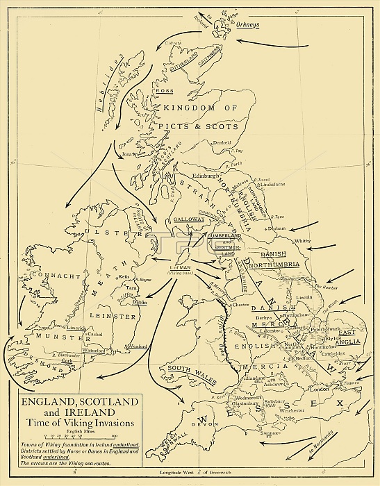
'England, Scotland and Ireland - Time of Viking Invasions', 1926. Map of Britain during the 9th-11th century. 'Towns of Viking foundation in Ireland underlined. Districts settled by Norse or Danes in England and Scotland are underlined. The arrows are the Viking sea routes.' From "History of England", by George Macaulay Trevelyan. [Longmans, Green and Co. Ltd, London, 1926]
| px | px | dpi | = | cm | x | cm | = | MB |
Details
Creative#:
TOP24718486
Source:
達志影像
Authorization Type:
RM
Release Information:
須由TPG 完整授權
Model Release:
No
Property Release:
No
Right to Privacy:
No
Same folder images:
seaEnglandartsWalescountrycoastlineDenmarkDanishbookoccupationgeographyattackIrelandScotlandvikinglocationcenturyinvasioncartographyliteratureconceptNorthSeaCelticGreatBritaintwentiesB&WMONOCHROMEblack&whiteblackandwhiteB/W1920s20thcenturyThePrintCollectorAngloSaxonAnglo-Saxongeographicalfeaturemap-makingTGNmapUnknownWalker&BoutallLongman&CoEmeryWalkerLtdoccupiedterritoryHistoryofEnglandLongmanRoberts&GreenWalkerEmeryLtdEmeryWalkerLimitedBoutallWalker&Walker&CockerellCockerellWalker&GeorgeMacaulayTrevelyanTrevelyanGeorgeMacaulayLongmansGreenandCo
&&&&&&&1920s20thAngloAnglo-SaxonB&WB/WBoutallBoutallBritainCelticCoCoCockerellCockerellCollectorDanishDenmarkEmeryEmeryEmeryEnglandEnglandGeorgeGeorgeGreatGreenGreenHistoryIrelandLimitedLongmanLongmanLongmansLtdLtdMONOCHROMEMacaulayMacaulayNorthPrintRobertsSaxonScotlandSeaTGNTheTrevelyanTrevelyanUnknownWalesWalkerWalkerWalkerWalkerWalkerWalkerWalkerandandartsattackblackblackbookcartographycenturycenturycoastlineconceptcountryfeaturegeographicalgeographyinvasionliteraturelocationmapmap-makingoccupationoccupiedofseaterritorytwentiesvikingwhitewhite
 Loading