
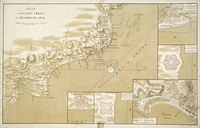
WALMER CASTLE, Kent. Plan of the coast of Kent from Ramsgate to Rye 1740. Chart of the approaches to the Kent coast showing details of the coastal defences at Sandwich, Deal, Dover, Walmer and Sandgate. Map WALMER CASTLE, Kent. 'Plan of the coast of Kent from Ramsgate to Rye' 1740. Chart of the approaches to the Kent coast showing details of the coastal defences at Sandwich, Deal, Dover, Walmer and Sandgate. Map
| px | px | dpi | = | cm | x | cm | = | MB |
Details
Creative#:
TOP24015162
Source:
達志影像
Authorization Type:
RM
Release Information:
須由TPG 完整授權
Model Release:
No
Property Release:
No
Right to Privacy:
No
Same folder images:
walmercastlekentplanthecoastkentfromramsgatetorye1740charttheapproachestothekentcoastshowingdetailsthecoastaldefencessandwichdealdoverwalmersandgatemapwalmercastlekent'planthecoastkentfromramsgatetorye'1740charttheapproachestothekentcoastshowingdetailsthecoastaldefencessandwichdealdoverwalmersandgatemapartefactgeorgianhistoryhistorical
'plan17401740approachesapproachesartefactcastlecastlechartchartcoastcoastcoastcoastcoastalcoastaldealdealdefencesdefencesdetailsdetailsdoverdoverfromfromgeorgianhistoricalhistorykentkentkentkentkentkentmapmapplanramsgateramsgateryerye'sandgatesandgatesandwichsandwichshowingshowingthethethethethethethethetotototowalmerwalmerwalmerwalmer
 Loading