
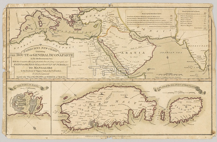
Three printed coloured maps: Fairburn's New Chart Exhibiting the Route of General Buonaparte in the Mediterranean Sea; with the Countries through which the French Army must pass, viz Egypt and the Red Sea; or the Gulf of Persia, & to Mangalore in the Territory of Tippoo Sahib, in the East Indies. To which is annexed A Particular Plan of the Island and Harbour of Malna. Published 13 Aug 1798. Associated with the Wars of the French Revolution, Egypt (1799-1801).
| px | px | dpi | = | cm | x | cm | = | MB |
Details
Creative#:
TOP23968954
Source:
達志影像
Authorization Type:
RM
Release Information:
須由TPG 完整授權
Model Release:
No
Property Release:
No
Right to Privacy:
No
Same folder images:
threeprintedcolouredmapsfairburn'snewchartexhibitingroutegeneralbuonapartemediterraneanseacountriesthroughfrencharmymustpassvizegyptredgulfpersiaandmangaloreterritorytippoosahibeastindiesannexedparticularplanislandharbourmalnapublished13aug1798associatedwarsrevolution17991801map4thmysorewartheofatoinwithorwhichhistoryhistorical
131798179918014thaandannexedarmyassociatedaugbuonapartechartcolouredcountrieseastegyptexhibitingfairburn'sfrenchgeneralgulfharbourhistoricalhistoryinindiesislandmalnamangaloremapmapsmediterraneanmustmysorenewoforparticularpasspersiaplanprintedpublishedredrevolutionroutesahibseaterritorythethreethroughtippootovizwarwarswhichwith
 Loading