
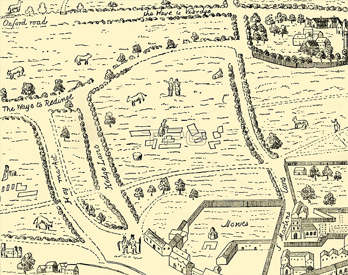
'The Site of Leicester Square', (1881). Map showing the countryside in what would later become Westminster, London. Roads marked include Haymarket and St Martin's Lane. Leicester Square was laid out in 1670. From Old and New London: A Narrative of Its History, Its People, and Its Places. Westminster and the Western Suburbs, by Edward Walford, Vol. III. [Cassell, Petter, Galpin & Co., London, Paris & New York, 1881]
| px | px | dpi | = | cm | x | cm | = | MB |
Details
Creative#:
TOP23172955
Source:
達志影像
Authorization Type:
RM
Release Information:
須由TPG 完整授權
Model Release:
No
Property Release:
No
Right to Privacy:
No
Same folder images:
citycountrysideroadLondonEnglandfieldfieldsjobsquarestreetcountryoccupationBritishEnglishlaneavenueWestminsterfarmlandlocationcenturyBritainprofessionB&WMONOCHROMEhaymarketleicestersquarepublication19thcenturyblack&whiteblackandwhiteB/Wpublisher16thcenturynineteenthcenturysixteenthcenturyCityofWestminsterThePrintCollectorTGNmapOldandNewLondonCassellEdwardWalfordEdwardWalfordPrintCollector29Cassell&CompanyLtdPetterGalpin&CoGalpin&Company
&&&&16th19thB&WB/WBritainBritishCassellCassellCityCoCollectorCollector29CompanyCompanyEdwardEdwardEnglandEnglishGalpinGalpinLondonLondonLtdMONOCHROMENewOldPetterPrintPrintTGNTheWalfordWalfordWestminsterWestminsterandandavenueblackblackcenturycenturycenturycenturycenturycitycountrycountrysidefarmlandfieldfieldshaymarketjoblaneleicesterlocationmapnineteenthoccupationofprofessionpublicationpublisherroadsixteenthsquaresquarestreetwhitewhite
 Loading