
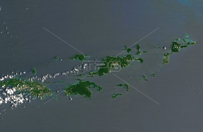
Caribbean islands (left to right) St. Thomas, St. John, Tortola and Virgin Gorda, in an image captured by the Landsat 8 satellite on August 25, 2017. Days later, Category 5 Hurricane Irma swept across the region, damaging or destroying buildings and infrastructure and browning the islands' lush vegetation.
| px | px | dpi | = | cm | x | cm | = | MB |
Details
Creative#:
TOP22318143
Source:
達志影像
Authorization Type:
RM
Release Information:
須由TPG 完整授權
Model Release:
N/A
Property Release:
No
Right to Privacy:
No
Same folder images:
foliagevegetation2017landsat8categoryfivecategory5seriesbeforehurricaneirmahurricanevirgingordatortolasaintjohnstjohnsaintthomasstthomasunitedstatesvirginislandsbvibritishvirginislandsvirginislandsusvirginislandsusvileewardislandsislandcaribbeansatelliteimagesatellitesatellitephotographyearthobservationviewfromaboveaerialviewaerialphotographyaerialscience
582017aboveaerialaerialaerialbeforebritishbvicaribbeancategorycategoryearthfivefoliagefromgordahurricanehurricaneimageirmaislandislandsislandsislandsislandsislandsjohnjohnlandsatleewardobservationphotographyphotographysaintsaintsatellitesatellitesatellitescienceseriesstststatesthomasthomastortolaunitedususvivegetationviewviewvirginvirginvirginvirginvirgin
 Loading