
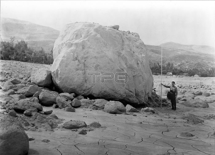
Peru Earthquake May 31, 1970. Block of granodiorite (estimated to weigh 700 tons) that was transported by the Huascaran debris avalanche to near the site of the former town of Ranrahirca. The top of the block is covered with mud and rock fragments deposited by the avalanche after the block came to rest. The 1970 Ancash earthquake was an undersea earthquake. Combined with a resultant landslide, it was the worst catastrophic natural disaster ever recorded in the history of Peru. The epicenter of the earthquake was located 35 km off the coast of Casma and Chimbote on the Pacific Ocean, where the Nazca Plate is being subducted by the South American Plate. It had a magnitude of 7.9 to 8.0 on the Richter scale and an intensity of up to VIII on the Mercalli scale. No significant tsunami was reported. The earthquake struck on a Sunday afternoon at 15:23:31 local time (20:23:31 UTC) and lasted 45 seconds. The quake destabilized the northern wall of Mount Huascar獺n, causing a rock, ice and snow avalanche and burying the towns of Yungay and Ranrahirca. An AP dispatch on July 14 said Peru's Minister of Health estimated the number of dead and missing persons to be 70,000. It may be impossible ever to assess fully the toll of this seismic disaster.
| px | px | dpi | = | cm | x | cm | = | MB |
Details
Creative#:
TOP22162715
Source:
達志影像
Authorization Type:
RM
Release Information:
須由TPG 完整授權
Model Release:
N/A
Property Release:
No
Right to Privacy:
No
Same folder images:
 Loading