
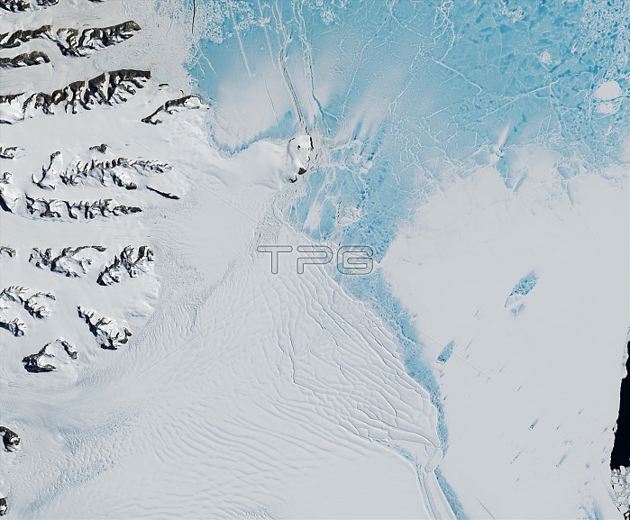
The Scar Inlet Ice Shelf, the southern remnant of Larsen B, captured by the Operational Land Imager (OLI) on Landsat 8 on January 6, 2016. The rest of Larsen B collapsed in 2002.
| px | px | dpi | = | cm | x | cm | = | MB |
Details
Creative#:
TOP22096578
Source:
達志影像
Authorization Type:
RM
Release Information:
須由TPG 完整授權
Model Release:
N/A
Property Release:
No
Right to Privacy:
No
Same folder images:
fissureriftthinningretreatingshrinkingglobalwarmingclimatechangeenvironmentalsciencepolarenvironmentantarcticcoast2016imageryobservationlandsatphotosatellitephotographyearthfromspacefromabovelandscapelandformgeologicalgeologicformationgeologygeographyoperationallandimagerolilandsat8landsatremnanticywatermelt-watermeltwatermeltingicetidewaterglacierscoastalglaciercoastlinefasticeseaicefloatingiceiceshelfaerialviewsatelliteimageantarcticalarsenbscarinleticeshelf
82016aboveaerialantarcticantarcticabchangeclimatecoastcoastalcoastlineearthenvironmentenvironmentalfastfissurefloatingformationfromfromgeographygeologicgeologicalgeologyglacierglaciersglobaliceiceiceiceiceiceicyimageimagerimageryinletlandlandformlandsatlandsatlandsatlandscapelarsenmelt-watermeltingmeltwaterobservationolioperationalphotophotographypolarremnantretreatingriftsatellitesatellitescarscienceseashelfshelfshrinkingspacethinningtidewaterviewwarmingwater
 Loading