
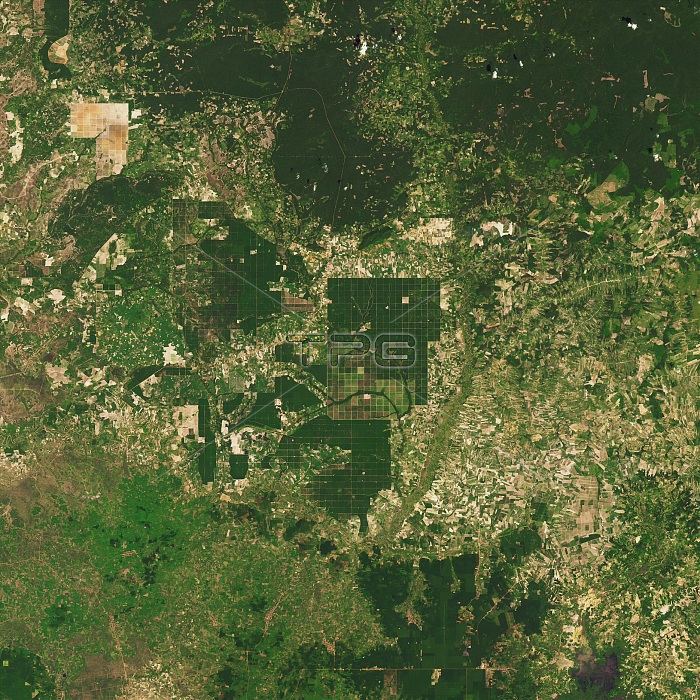
Cambodia's landscape near the border of the Kampong Thom and Kampong Cham provinces, as seen by the Operational Land Imager (OLI) on Landsat 8, on October 30, 2015. Compare this photo with the one taken of the same area in 2000, when much of the area was forest. Cambodia has one of the fastest rates of forest loss in the world. Here the forest has been cleared for agricultural fields, timber production and large-scale rubber plantations.
| px | px | dpi | = | cm | x | cm | = | MB |
Details
Creative#:
TOP22096398
Source:
達志影像
Authorization Type:
RM
Release Information:
須由TPG 完整授權
Model Release:
N/A
Property Release:
No
Right to Privacy:
No
Same folder images:
clearcutclearcuttropicaljungledegradeddamagedestructionclearancenewroadslandusefragmentationhabitatdegradationecologicalissueenvironmentalproblemenvironmentgeography2010imageryobservationlandsatphotosatellitephotographyaerialearthfromspaceoperationallandimagerolilandsat8landsatbeforeandaftersequenceseriesasianrainforestsoutheastasiacambodiankampongthomkampongchamfarmlandagriculturalfieldagricultureloggingtimberproductionrubberplantationforestlossdeforesteddeforestationaerialviewsatelliteimagecambodiarainforestforest
82010aerialaerialafteragriculturalagricultureandasiaasianbeforecambodiacambodianchamclearclearanceclearcutcutdamagedeforestationdeforesteddegradationdegradeddestructionearthecologicalenvironmentenvironmentalfarmlandfieldforestforestforestfragmentationfromgeographyhabitatimageimagerimageryissuejunglekampongkamponglandlandlandsatlandsatlandsatlogginglossnewobservationolioperationalphotophotographyplantationproblemproductionrainrainforestroadsrubbersatellitesatellitesequenceseriessoutheastspacethomtimbertropicaluseview
 Loading