
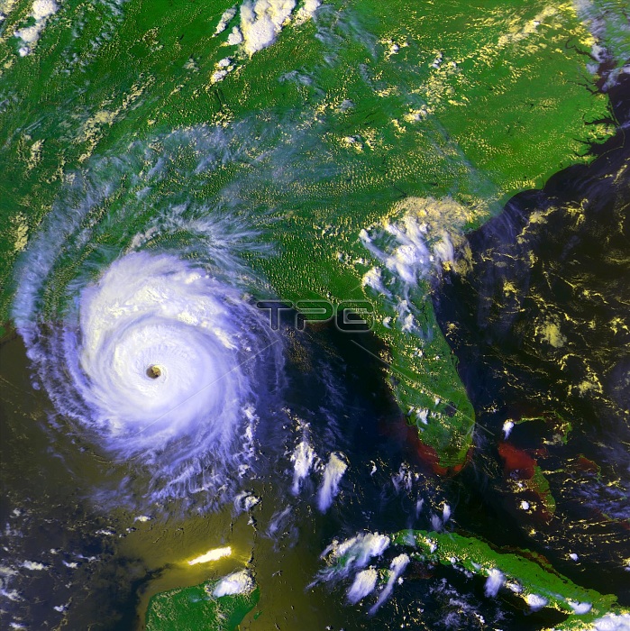
Image of Andrew was taken on August 25, 1992, at 20:20 UT. Looking at the image, one can see Andrew's path laid out behind it in the form of churned-up, reddish brown ocean sediments and residual cloud cover. Flooding can be seen along the coast of south Florida. The cloud data are from the National Atmospheric and Oceanic Administration's (NOAA) Geostationary Operational Environmental Satellite (GOES), and the vegetation is derived from Advanced Very High Resolution Radiometers (AVHRR) aboard NOAA's operational satellites.
| px | px | dpi | = | cm | x | cm | = | MB |
Details
Creative#:
TOP22094037
Source:
達志影像
Authorization Type:
RM
Release Information:
須由TPG 完整授權
Model Release:
N/A
Property Release:
No
Right to Privacy:
No
Same folder images:
20thcentury1990s1992august25thaugust25goesimagesatelliteimagegoessatellitegoessatelliteimagegeostationaryoperationalenvironmentalsatellitedeadliestcostliesttropicalcyclonecategory5hurricaneandrewhistoricalhistorichistoryhazardoushazarddangerousdangernaturaldisasterstrongweatherstormviolentsevereintenseweathereventweathernaturalphenomenonnaturalphenomenaphenomenonphenomenameteorologicalmeteorologyatmosphericconditionsatmosphericscience
1990s199220th25th525andrewatmosphericatmosphericaugustaugustcategorycenturyconditionscostliestcyclonedangerdangerousdeadliestdisasterenvironmentaleventgeostationarygoesgoesgoeshazardhazardoushistorichistoricalhistoryhurricaneimageimageimageintensemeteorologicalmeteorologynaturalnaturalnaturaloperationalphenomenaphenomenaphenomenonphenomenonsatellitesatellitesatellitesatellitescienceseverestormstrongtropicalviolentweatherweatherweather
 Loading