
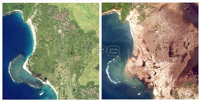
Aceh, Indonesia, before and after the southeast Asian earthquake and tsunami of December 26, 2004. The image on the left is from January 10, 2003; the image on the right, showing massive devastation, is from December 29, 2004. The Indonesian province of Aceh was hit hardest by the earthquake and tsunamis. Aceh is located on the northern tip of the island of Sumatra. Early Western media attention was focused on Sri Lanka and Thailand, even though the earthquake epicenter was closer to Aceh, and the largest waves struck the northwestern coast of Sumatra. On Decemebr 29, estimates of the death toll in Indonesia were over 80,000, more than half the global total. The town of Lhoknga, on the west coast of Sumatra near the capital of Aceh, Banda Aceh, was completely destroyed by the tsunami, with the exception of the mosque in the city's center. These high-resolution satellite images show Lhoknga before (left) and after (right). Almost all the trees, vegetation, and buildings in the area were washed away. Behind the town, low-lying agricultural areas remained covered with water 4 days after the disaster, and sand on the nearby beaches was completely removed. The wave height might have exceeded 15 meters (50 feet) when it struck the shore. Equivalent devastation extends 225 km southeast along the Sumatran Coast, in a band up to 3 km (1.9 miles) deep.
| px | px | dpi | = | cm | x | cm | = | MB |
Details
Creative#:
TOP22089600
Source:
達志影像
Authorization Type:
RM
Release Information:
須由TPG 完整授權
Model Release:
N/A
Property Release:
No
Right to Privacy:
No
Same folder images:
 Loading