
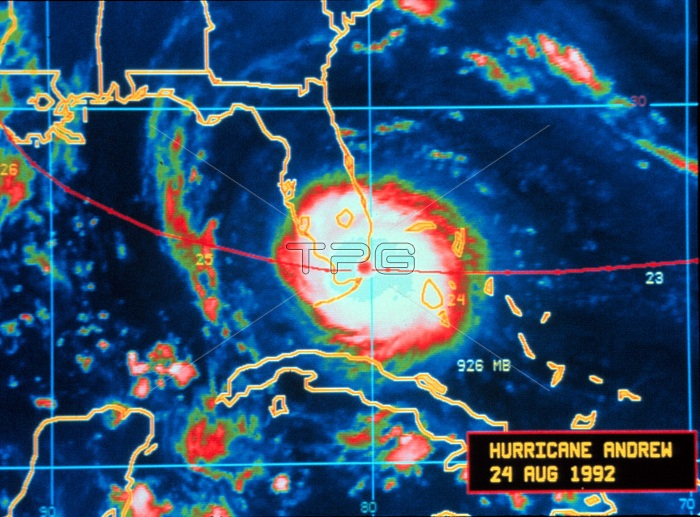
Hurricane Andrew-infrared image taken by GOES 7 Andrew is crossing the Florida coast and making landfall August 24, 1992, at Dade County, Florida. GOES 7, known as GOES-H before becoming operational, is an American satellite. It was originally built as a weather satellite, and formed part of the US National Oceanic and Atmospheric Administration's Geostationary Operational Environmental Satellite system. As of 2009, it is operational over the Pacific Ocean, providing communications for the Pacific Islands.
| px | px | dpi | = | cm | x | cm | = | MB |
Details
Creative#:
TOP22088229
Source:
達志影像
Authorization Type:
RM
Release Information:
須由TPG 完整授權
Model Release:
N/A
Property Release:
No
Right to Privacy:
No
Same folder images:
20thcenturyenvironmentalsatellitesystemnoaaweathersatellitesatellitegoes7goes-hcoastfloridaweathertrackingweatherpatternsweatherpredictionweatherforecastingweatherdatainfraredsatelliteimagingsatelliteimageatlantichurricanelandfallcategory5deadlycostly1992augustmaximumintensitycyclonicstormcyclonetropicalstormhurricaneandrewnwsnationalweatherserviceusausunitedstatesamericanamericastrongweatherstormviolentsevereintenseweathereventweathernaturalphenomenonnaturalphenomenameteorologicalmeteorologyatmosphericconditionsatmosphericscience
199220th57americaamericanandrewatlanticatmosphericatmosphericaugustcategorycenturycoastconditionscostlycyclonecyclonicdatadeadlyenvironmentaleventfloridaforecastinggoesgoes-hhurricanehurricaneimageimaginginfraredintenseintensitylandfallmaximummeteorologicalmeteorologynationalnaturalnaturalnoaanwspatternsphenomenaphenomenonpredictionsatellitesatellitesatellitesatellitesatellitescienceserviceseverestatesstormstormstormstrongsystemtrackingtropicalunitedususaviolentweatherweatherweatherweatherweatherweatherweatherweatherweatherweather
 Loading