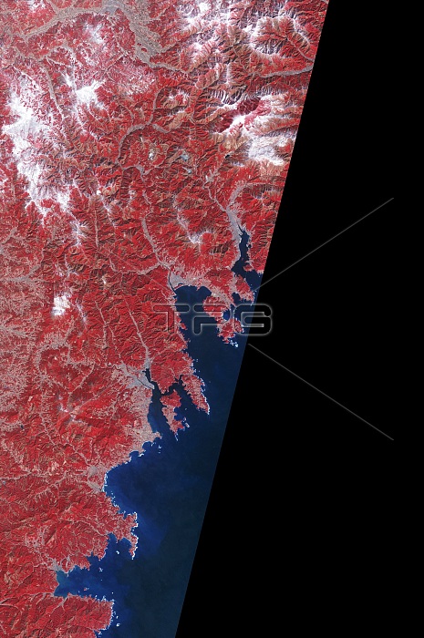
Color-enhanced satellite view of the Japanese city of Rikuzentakata, one of the locations hardest hit by the earthquake and tsunami of March 11, 2011, under normal conditions. For a comparison of the same location after the tsunami, see image BS0543.
| px | px | dpi | = | cm | x | cm | = | MB |
Details
Creative#:
TOP22087021
Source:
達志影像
Authorization Type:
RM
Release Information:
須由TPG 完整授權
Model Release:
N/A
Property Release:
No
Right to Privacy:
No
Same folder images:
sequenceseriesphotosequencephotoseriescomparisonafterbeforebefore&afterbeforeandafterfalsecolorcolor-enhancedcolorenhancedfalse-colorinfraredcoastlinerikuzentakataterrasatelliteastersatellitedevastateddevastationfloodfloodedfloodingfromaboveaerialaerialphotographaerialphotographyaerialphotoaerialviewsatellitephotographysatellitephotofromspaceviewfromspaceearthfromspacesatelliteviewdisastertopographicaltopographygeologicalgeologygeologicalhazardseismicquakemarch11naturaldisastertsunamiearthquakejapanearthquakejapantsunamijapan
&11aboveaerialaerialaerialaerialaerialafterafterafterandasterbeforebeforebeforecoastlinecolorcolorcolor-enhancedcomparisondevastateddevastationdisasterdisasterearthearthquakeearthquakeenhancedfalsefalse-colorfloodfloodedfloodingfromfromfromfromgeologicalgeologicalgeologyhazardinfraredjapanjapanjapanmarchnaturalphotophotophotophotophotographphotographyphotographyquakerikuzentakatasatellitesatellitesatellitesatellitesatelliteseismicsequencesequenceseriesseriesspacespacespaceterratopographicaltopographytsunamitsunamiviewviewview

 Loading