
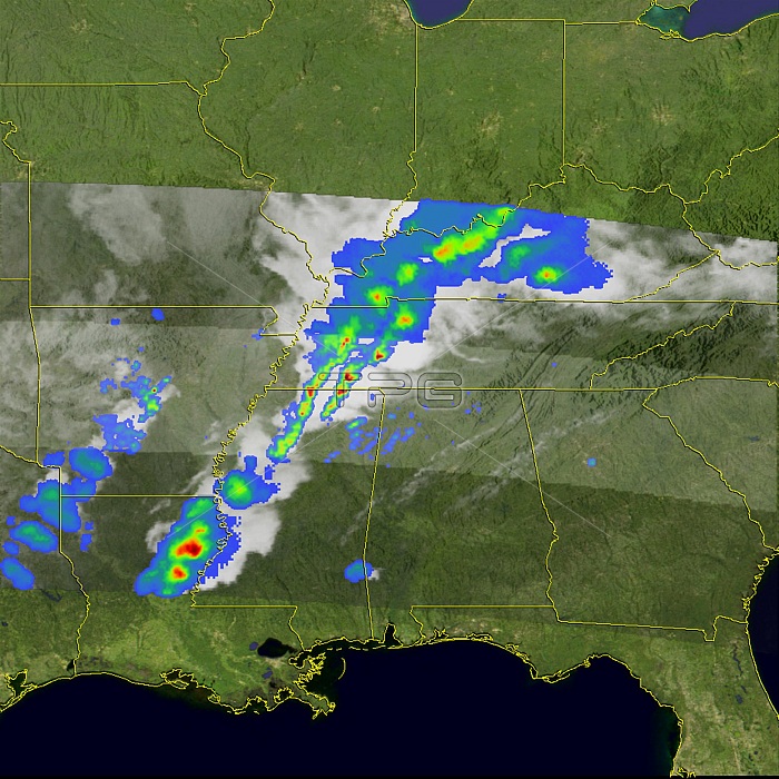
A major wintertime tornado outbreak ripped through Arkansas, western Tennessee, northern Mississippi, northern Alabama, and western Kentucky on February 5, 2008. By the afternoon of the next day, at least 52 fatalities had been reported, said news reports. At least 26 people were reported to have died in Tennessee alone. The tornadoes were spawned from a line of severe thunderstorms that moved eastward across the region. The Tropical Rainfall Measuring Mission satellite (TRMM) captured these unique images of the line of severe storms. The images were taken at 11:08 p.m. Central Daylight Time on February 5, (05:08 UTC on February 6) as the storms moved out of the lower Mississippi valley into the Ohio and Tennessee valleys. The first image shows the horizontal distribution of rain intensity as seen from above. A line of intense rainfall (darker reds) associated with the heavier thunderstorms stretches from northeastern Louisiana up through Mississippi, western Tennessee and Kentucky, and into southern Indiana. The northern part of the line contains a broader area of light to moderate rain (green and blue areas). The rain rates shown in the center of this image are from the TRMM precipitation radar, the first and only space-borne precipitation radar. In addition to the precipitation radar, TRMM uses an array of passive and active sensors to measure rainfall from space. Rain rates in the outer swath are from the TRMM Microwave Imager. The rain rates are overlaid on infrared data from the TRMM Visible Infrared Scanner. The powerful storms were fed by warm moist air from the Gulf of Mexico.
| px | px | dpi | = | cm | x | cm | = | MB |
Details
Creative#:
TOP22084152
Source:
達志影像
Authorization Type:
RM
Release Information:
須由TPG 完整授權
Model Release:
N/A
Property Release:
No
Right to Privacy:
No
Same folder images:
 Loading