
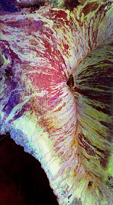
This image of the Mauna Loa volcano on the Big Island of Hawaii shows the capability of imaging radar to map lava flows and other volcanic structures. Mauna Loa has erupted more than 35 times since the island was first visited by westerners in the early 1800s. The large summit crater, called Mokuaweoweo Caldera, is clearly visible near the center of the image. Leading away from the caldera (towards top right and lower center) are the two main rift zones shown here in orange. Rift zones are areas of weakness within the upper part of the volcano that are often ripped open as new magma (molten rock) approaches the surface at the start of an eruption. The most recent eruption of Mauna Loa was in March and April 1984, when segments of the northeast rift zones were active. If the height of the volcano was measured from its base on the ocean floor instead of from sea level, Mauna Loa would be the tallest mountain on Earth. Its peak (center of the image) rises more than 8 kilometers (5 miles)
| px | px | dpi | = | cm | x | cm | = | MB |
Details
Creative#:
TOP22083194
Source:
達志影像
Authorization Type:
RM
Release Information:
須由TPG 完整授權
Model Release:
N/A
Property Release:
No
Right to Privacy:
No
Same folder images:
 Loading