
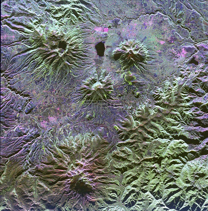
A family of dormant volcanoes dominates the landscape in this radar image of the Andes Mountains in northern Ecuador. The city of Otavalo, shown in pink, and Lake Otavalo lie within the triangle formed by three volcanoes in the upper part of the image. These volcanoes are, clockwise from upper left, Mojanda, Imabura and Cusin. A lake partially fills the summit crater of Mojanda and a group of lava domes can be seen on the north flank. Geologists believe the most recent eruption of Mojanda was about 3,400 years ago. Much more recent activity has occurred at Cayambe, the large volcano at the bottom of the image. Massive mudflow deposits can be seen filling the valleys on the east (right) side of Cayambe. Cayambe last erupted about 600 years ago. Geologists are using radar to study volcanoes in the Andes to determine the history of eruptions and to identify potential threats the volcanoes pose to local communities.....This image was acquired by the Spaceborne Imaging Radar-C/X-Band Synthetic Aperture Radar (SIR-C/X-SAR) aboard the space shuttle Endeavour on April 14, 1994.
| px | px | dpi | = | cm | x | cm | = | MB |
Details
Creative#:
TOP22083172
Source:
達志影像
Authorization Type:
RM
Release Information:
須由TPG 完整授權
Model Release:
N/A
Property Release:
No
Right to Privacy:
No
Same folder images:
 Loading