
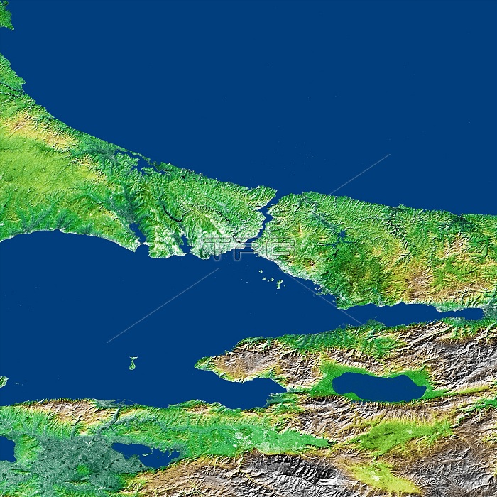
The Bosporus (also spelled Bosphorus) is a strait that connects the Black Sea with the Sea of Marmara in the center of this view of northwest Turkey, taken during the Shuttle Radar Topography Mission. The water of the Black Sea at the top of the image and Sea of Marmara below the center are colored blue in this image, along with several large lakes. The largest lake, to the lower right of the Sea of Marmara, is Iznik Lake. The Bosporus(Turkish Bogazici) Strait is considered to be the boundary between Europe and Asia, and the large city of Istanbul, Turkey is located on both sides of the southern end of the strait, visible as a brighter(light green to white) area on the image due to its stronger reflection of radar. Three visualization methods were combined to produce this image: shading and color coding of topographic height and radar image intensity.
| px | px | dpi | = | cm | x | cm | = | MB |
Details
Creative#:
TOP22083106
Source:
達志影像
Authorization Type:
RM
Release Information:
須由TPG 完整授權
Model Release:
N/A
Property Release:
No
Right to Privacy:
No
Same folder images:
 Loading