
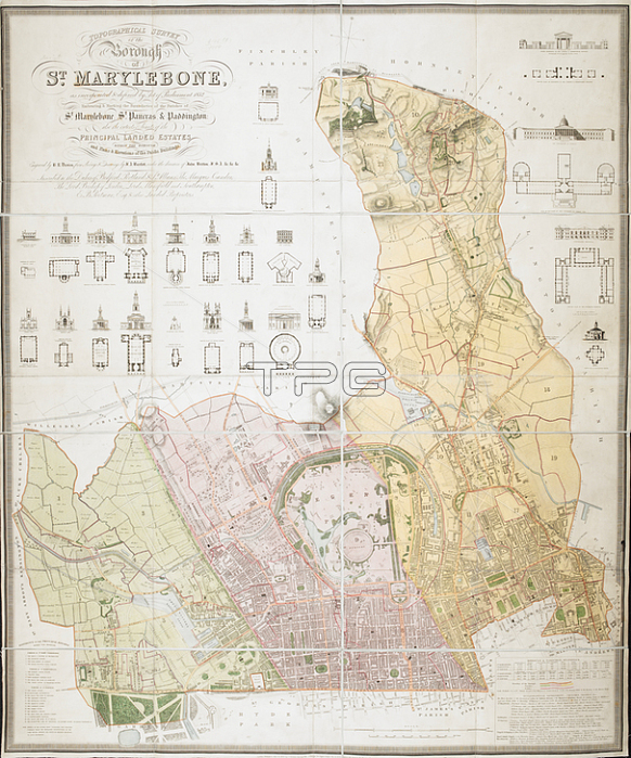
Benjamin Rees Davies.Topographical survey of the borough of St. Marylebone; as incorporated & defined by Act of Parliament 1832.: Embracing & marking the boundaries of the parishes of St. Marylebone; St. Pancras; & Paddington; also the extents & limits of the principal landed estates within the borough; and plans & elevations of the public buildings Boundaries outlined in colour; map coloured and numbered for reference with a key at bottom left and note on parishes at bottom right. Relief shown by hachures. Supplies elevations and ground plans of prominent buildings.London: Published by J. Britton; Burton Str. J. Taylor; 30 Upper Gower Str. & B.R. Davies; 16 George Str. Euston Squ: ; June 25; 1837.From: Benjamin Rees Davies; Topographical survey of the borough of St. Marylebone; as incorporated & defined by Act of Parliament 1832.: Embracing & marking the boundaries of the parishes of St. Marylebone; St. Pancras; & Paddington; also the extents & limits of the principal landed estates within the borough; and plans & elevations of the public buildings / Engraved by B.R. Davies from surveys & drawings by F.A. Bartlett under the direction of John Britton F.S.A. &c. &c. &c.Maps Crace Port. 1London; British Library.
| px | px | dpi | = | cm | x | cm | = | MB |
Details
Creative#:
TOP21010408
Source:
達志影像
Authorization Type:
RM
Release Information:
須由TPG 完整授權
Model Release:
No
Property Release:
No
Right to Privacy:
No
Same folder images:
Restriction:
Additional permissions needed for non-editorial use.
 Loading