
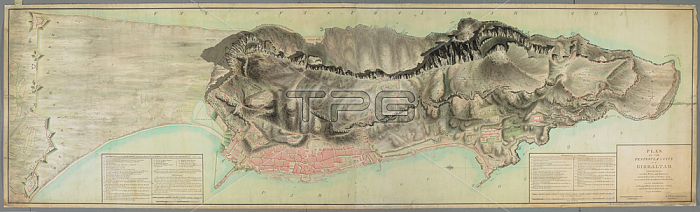
William Green.A map showing the state of fortifications and defences at the time of the Great Siege of Gibraltar 1779-1783; during which undisturbed work was going on to strengthen the defences.[Gibraltar?]: [Paterson; Green and Chamberlain]; [about 1780.].From: William Green; PLAN OF THE PENINSULA & CITY OF GIBRALTAR: EXHIBITING our New Works and Batteries erected since the 21st. of June 1779 on account of the Investiture of this Fortress; ALSO SHEWING the Enemy's Works which they have erected behind their Lines & Forts; which run across the Isthmus; The Original dated at Gibraltar 10th. Febry. 1780. By Willm. Green Chief Engineer and Colonel.Maps K. Top. 72.40.1.2. TABLondon; British Library.
| px | px | dpi | = | cm | x | cm | = | MB |
Details
Creative#:
TOP21007122
Source:
達志影像
Authorization Type:
RM
Release Information:
須由TPG 完整授權
Model Release:
No
Property Release:
No
Right to Privacy:
No
Same folder images:
Restriction:
Additional permissions needed for non-editorial use.
 Loading