
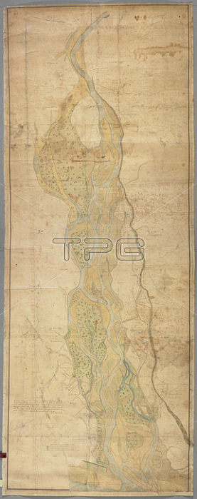
A map of the River Spey.[Scotland?]: by William Adam Arch. t; [1732.].From: General Mapp of the River=Spey from the Reid-rock above the Boat att Focaber downward to the Sea being four measured miles in length.: Wherein is Expresst the Main Alvis of the River with the different Strims that run therefrom; Banks of Channel; and green=ground whereof some part arrable; and others not; Those parts mark'd with the Bushes are whins and of a small value; this Mapp expresses the Exact figure of the whole; as it was in the last week of October and first two weeks of November 1732; when the same was Survey'd / by William Adam Arch. t.Maps K. Top. 48.78London; British Library.
| px | px | dpi | = | cm | x | cm | = | MB |
Details
Creative#:
TOP21006970
Source:
達志影像
Authorization Type:
RM
Release Information:
須由TPG 完整授權
Model Release:
No
Property Release:
No
Right to Privacy:
No
Same folder images:
Restriction:
Additional permissions needed for non-editorial use.
 Loading