
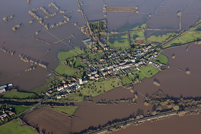
Flooding around East Lyng, Somerset, 2014. At the end of the 9th century AD King Alfred the Great established a burh, or fortified settlement, at the eastern end of the Lyng ridge. The town was linked to the nearby stronghold and monastery at Athelney, founded by Alfred a few years earlier, and all were surrounded by the marshes of the Somerset Levels. This image, taken at the height of the flooding in the winter of 2013-2014, shows the logic behind the location of the settlement, now called East Lyng.
| px | px | dpi | = | cm | x | cm | = | MB |
Details
Creative#:
TOP20710636
Source:
達志影像
Authorization Type:
RM
Release Information:
須由TPG 完整授權
Model Release:
No
Property Release:
No
Right to Privacy:
No
Same folder images:
weatherwatercountrysideEnglandlandscapecountryunderwaterBritishEnglishcolorcoloursubmergedvillagerusticlocationdisastercenturyfloodedBritaincatastropheconceptfloodsSomersetnaturaldisaster21stcenturyfloodingaerialviewbird'seyeviewaerialphotographyinundationruralEnglishHeritagerurallifeSomersetLevelsTGNEnglishHeritagephotographfloodwater2010sDamianGradyGradyDamianEastLyng
2010s21stBritainBritishDamianDamianEastEnglandEnglishEnglishEnglishGradyGradyHeritageHeritageLevelsLyngSomersetSomersetTGNaerialaerialbird'scatastrophecenturycenturycolorcolourconceptcountrycountrysidedisasterdisastereyefloodedfloodingfloodsfloodwaterinundationlandscapelifelocationnaturalphotographphotographyruralruralrusticsubmergedunderwaterviewviewvillagewaterweather
 Loading