
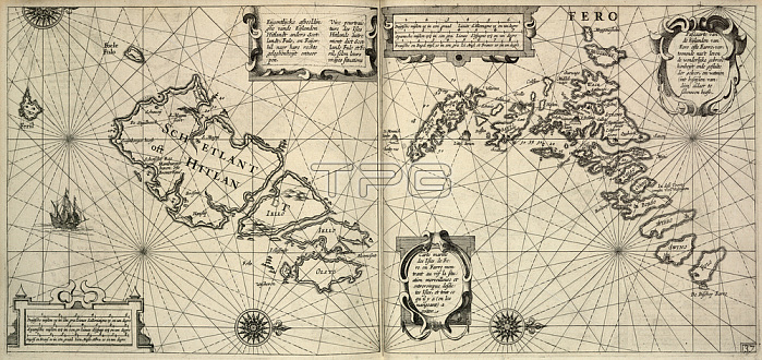
Faeroe Islands; Chart of the Faeroes or Faroe Islands.Image taken from [The Light of Navigation; wherein are declared and lively pourtrayed; all the Coasts and Havens; of the West; North and East Seas By William Johnson [i. e. Willem Janszoon Blaeu. Translated from Het Licht der Zee-vaert]. (The first book. pp. 114; and charts 1-6; 8-19. The second book. pp. 118; and charts 20-41) ]. 270 x 280 mm.Originally published / produced in Amsterdam: Jean Jeansson; 1620.Amsterdam: Jean Jeansson; 1620.From: [The Light of Navigation; wherein are declared and.Maps. C. 8. a. 2; no. 37London; British Library.
| px | px | dpi | = | cm | x | cm | = | MB |
Details
Creative#:
TOP20499940
Source:
達志影像
Authorization Type:
RM
Release Information:
須由TPG 完整授權
Model Release:
No
Property Release:
No
Right to Privacy:
No
Same folder images:
Restriction:
Additional permissions needed for non-editorial use.
 Loading