
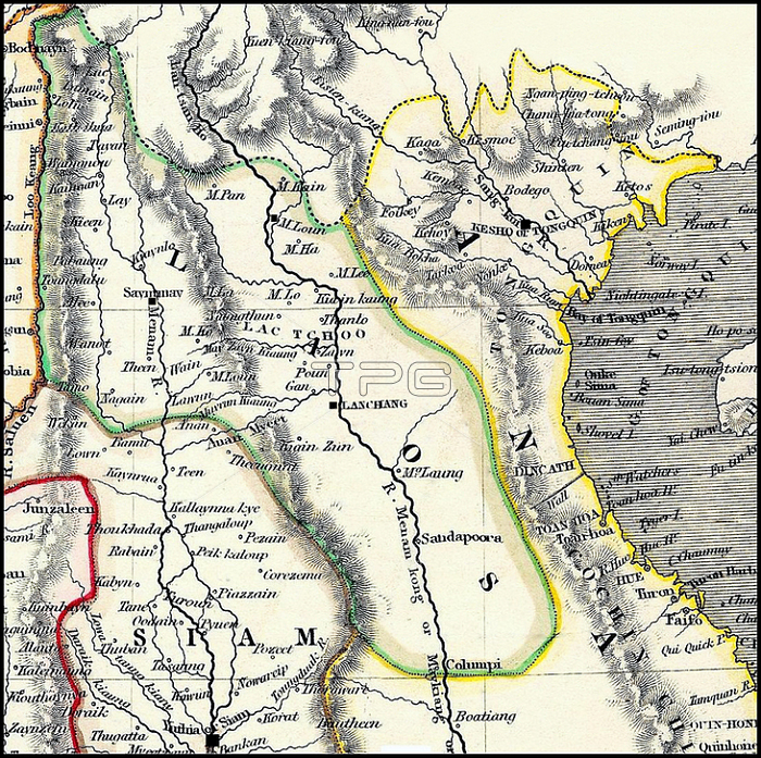
Detail of a British map dating from the early 19th century. Burma's Tenasserim Province (pink) is marked as being British and was seized by Britain after the First Anglo-Burmese War (1824-1826).
The geography is very imperfect; the first Brirish surveying teams into 'Laos Land' not being dispatched until the missions of McLeod and Richardson (1836-37). Chiang Mai; the Lan Na capital; at this time under the rule of Chao Phuttawong (1825-46); is identified as 'Saymamay'. The Lao capital; Vientiane; conquered and despoiled by Siam in 1828; is identified as Lanchang; and placed on the wrong; west bank of the Mekong River. Luang Prabang; to the north; is probably identified as (the more northerly) M. Loun.
Hanoi; the capital of Tonkin to the Northeast; is identified (puzzlingly) as 'Kesho' or 'Tongquin'; the latter being 'Eastern Capital' in Vietnamese. To the south; is still identified as the old capital of Siam; 'Yuthia' (Ayutthaya); although the capital was moved to Bangkok in 1782.
The River Salween is shown as the frontier between the Lan Na Kingdom and Burma; while the northernmost part of Lan Na is shown to extend north; into the Shan States in the region of Kengtung
| px | px | dpi | = | cm | x | cm | = | MB |
Details
Creative#:
TOP20184204
Source:
達志影像
Authorization Type:
RM
Release Information:
須由TPG 完整授權
Model Release:
No
Property Release:
No
Right to Privacy:
No
Same folder images:
 Loading