
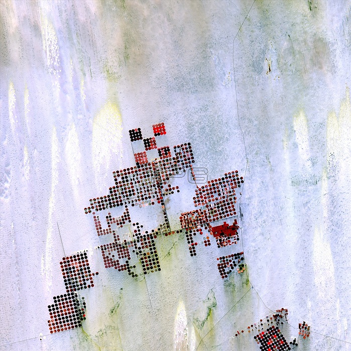
Centre-pivot irrigation in Sahara, satellite image. Each circular shape in the desert is a centre-pivot irrigation field that is just under a kilometre across. This area is in the Sahara Desert in southern Egypt. With no surface water in this region, wells pump underground water to rotating sprinklers from the huge Nubian Sandstone aquifer under the desert. Image data obtained by the Landsat 8 satellite on 22 May 2013.
| px | px | dpi | = | cm | x | cm | = | MB |
Details
Creative#:
TOP19653137
Source:
達志影像
Authorization Type:
RM
Release Information:
須由TPG 完整授權
Model Release:
N/A
Property Release:
N/A
Right to Privacy:
No
Same folder images:
AFRICANAGRICULTURALARIDEGYPTIANFARMINGFIELDSFROMSPACEGEOGRAPHICALIRRIGATEDIRRIGATIONSYSTEMNO-ONENOBODYNUBIANSANDSTONEAQUIFERPUMPSSAHARANSANDSANDYTECHNOLOGICALUNDERGROUNDWATERSUPPLYCENTRE-PIVOTIRRIGATIONFIELDFARMAFRICADESERTSAHARAEGYPTGEOGRAPHYEARTHOBSERVATIONAGRICULTURETECHNOLOGYHUMANGEOGRAPHYSATELLITEIMAGESATELLITELANDSATLANDSAT821STCENTURY201322MAY2013
8222013201321STAFRICANAGRICULTURALAGRICULTUREAQUIFERARIDCENTRE-PIVOTCENTURYDESERTEARTHEGYPTEGYPTIANFARMAFRICAFARMINGFIELDFIELDSFROMGEOGRAPHICALGEOGRAPHYGEOGRAPHYHUMANIMAGEIRRIGATEDIRRIGATIONIRRIGATIONLANDSATLANDSATMAYNO-ONENOBODYNUBIANOBSERVATIONPUMPSSAHARASAHARANSANDSANDSTONESANDYSATELLITESATELLITESPACESUPPLYSYSTEMTECHNOLOGICALTECHNOLOGYUNDERGROUNDWATER
 Loading