
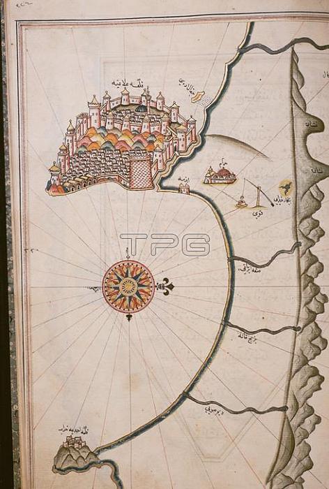
Cartography /Alanya (Province Antalya; South coast; Turkey).Map of the Bay of Alanya with the castle.Map by Ottoman cartograher Piri Reis (1470-1554/55).From the Kitab-i Bahriye (Seafarer's book) by Piri Reis(description of coasts and islands of the Mediterranean; begun 1521; finalised 1554/55).Opaque colours on paper.Ms TY 6605;Istanbul; Universit鋞sbibliothek.
| px | px | dpi | = | cm | x | cm | = | MB |
Details
Creative#:
TOP18175904
Source:
達志影像
Authorization Type:
RM
Release Information:
須由TPG 完整授權
Model Release:
No
Property Release:
No
Right to Privacy:
No
Same folder images:
16THCENTURYALANYAARTASIAASIAMINORATLASESCARTOGRAPHYCDCITYVIEWCITYSCAPECOASTSHORELINEGEOGRAPHYISLAMISLAMICWORLDISLAMICARTIstanbulUniversit鋞sbibliothekMAPMEDITERRANEANSEAMEDITERRANEANMINIATURE(PAINTING)PAINTING(TECHNIQUE)PIRIREISPORTRAITFORMATROLANDANDSABRINAMICHAUDROLANDMICHAUDSABRINAMICHAUDSCIENCESSCIENCESEATOPOGRAPHYTURKEY(COUNTRY)
(COUNTRY)(PAINTING)(TECHNIQUE)16THALANYAANDARTARTASIAASIAATLASESCARTOGRAPHYCDCENTURYCITYCITYSCAPECOASTFORMATGEOGRAPHYISLAMISLAMICISLAMICIstanbulMAPMEDITERRANEANMEDITERRANEANMICHAUDMICHAUDMICHAUDMINIATUREMINORPAINTINGPIRIPORTRAITREISROLANDROLANDSABRINASABRINASCIENCESCIENCESSEASEASHORELINETOPOGRAPHYTURKEYUniversit鋞sbibliothekVIEWWORLD
 Loading