
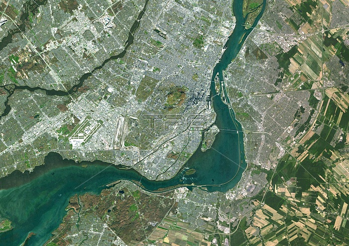
Montreal, Canada. Satellite image of Montreal, the largest city in Quebec, Canada. The city lies on the Island of Montreal at the confluence of the Saint Lawrence (dark, upper right) and Ottawa (dark, lower left) Rivers. Urban areas are grey and vegetation is green. Imaged by the Landsat 8 satellite, on 11th November 2014.
| px | px | dpi | = | cm | x | cm | = | MB |
Details
Creative#:
TOP16630925
Source:
達志影像
Authorization Type:
RM
Release Information:
須由TPG 完整授權
Model Release:
N/A
Property Release:
N/A
Right to Privacy:
No
Same folder images:
11november11/11/201411th201421stcenturyborderbordersboundariesboundarycanadacanadiancartographycityconfluencecountriescountryearthobservationenvironmentenvironmentalsciencefrenchcanadianfromabovefromspacefrontierfrontiersgeographicalgeographyislandofmontreallandlandsat8mapmontrealno-onenobodynorthamericanorthamericanottawariverquebecriverssaintlawrenceriversatelliteimageurban
81111/11/201411th201421staboveamericaamericanborderbordersboundariesboundarycanadacanadiancanadiancartographycenturycityconfluencecountriescountryearthenvironmentenvironmentalfrenchfromfromfrontierfrontiersgeographicalgeographyimageislandlandlandsatlawrencemapmontrealmontrealno-onenobodynorthnorthnovemberobservationofottawaquebecriverriverriverssaintsatellitesciencespaceurban
 Loading