
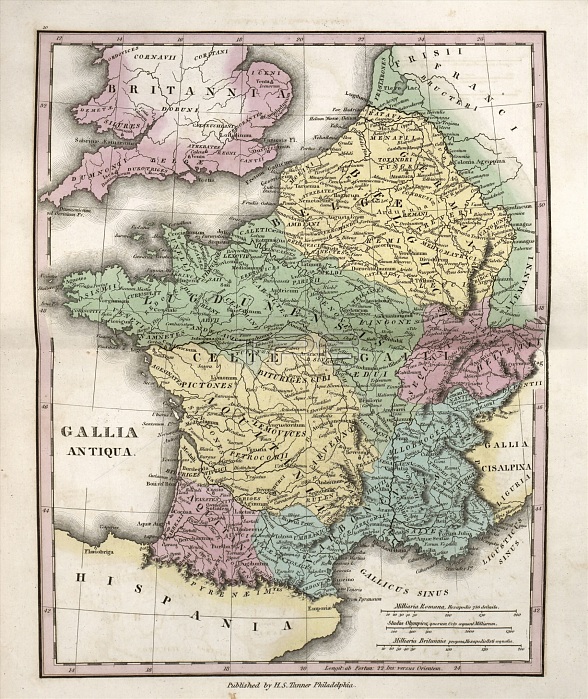
Map of Ancient Gaul, 19th century. This map of Ancient Gaul (Latin: Gallia) shows what is now mostly France. The map is divided by colour into regions such as Gallia Belgica (yellow), Gallia Lugdunensis (green), Gallia Aquitania (yellow) and Gallia Narbonensis (blue). Also named are many Celtic and non-Celtic tribes, such as the Belgae, Pictones, Bituriges, Aedui, Aquitani, Sequani, and Helvetii. The distance scales (lower right) are in Roman miles, Greek stadia, and British miles. Published in 'An Atlas of Ancient Geography' (1826) by US cartographer Henry Schenck Tanner (1786-1858).
| px | px | dpi | = | cm | x | cm | = | MB |
Details
Creative#:
TOP16426054
Source:
達志影像
Authorization Type:
RM
Release Information:
須由TPG 完整授權
Model Release:
N/A
Property Release:
N/A
Right to Privacy:
No
Same folder images:
1800s182619thcenturyaeduianatlasofancientgeographyancientgaulancientworldantiquityaquitaniartworkatlasbelgaebiturigesbookbritishmilescartographycelticclassicaldistancescalegalliaantiquagalliaaquitaniagalliabelgicagallialugdunensisgallianarbonensisgallicgeographicalgeographygreekstadiahelvetiihenryschencktannerhistoricalhistoryillustrationimperiallatinmapmilliariabritannicapropriamilliariaromanano-onenobodypagepictonesprovincepublicationromanempireromanmilesromanprovincesscalessequanistadiaolympicatribes
1800s182619thaeduianancientancientancientantiquaantiquityaquitaniaquitaniaartworkatlasatlasbelgaebelgicabiturigesbookbritannicabritishcartographycelticcenturyclassicaldistanceempiregalliagalliagalliagalliagalliagallicgaulgeographicalgeographygeographygreekhelvetiihenryhistoricalhistoryillustrationimperiallatinlugdunensismapmilesmilesmilliariamilliarianarbonensisno-onenobodyofolympicapagepictonespropriaprovinceprovincespublicationromanromanromanromanascalescalesschencksequanistadiastadiatannertribesworld
 Loading