
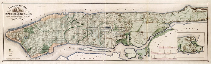
New York City topography. 19th-century topographical map of New York City and Manhattan Island, USA. The map shows the original waterways (green) that existed when the city was first founded, as well as reclaimed land (orange). At lower right are three cross-sections and an inset map of the northern tip of the island (North is at right). The Hudson River (North River) is at top, with the East River at bottom, and the Harlem River at right. Islands in the East River include Blackwell's Island (now Roosevelt Island) and Randalls Island and Wards Island. Published in 1865, this map was prepared by US civil engineer Egbert Ludovicus Viele (1825-1902).
| px | px | dpi | = | cm | x | cm | = | MB |
Details
Creative#:
TOP16313553
Source:
達志影像
Authorization Type:
RM
Release Information:
須由TPG 完整授權
Model Release:
N/A
Property Release:
N/A
Right to Privacy:
No
Same folder images:
 Loading