
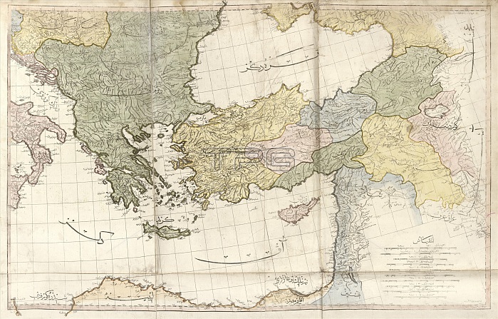
Greece and Turkey. Early 19th-century map of Greece and Turkey with labels in Ottoman Turkish. Places and regions shown include the Black Sea, the Aegean Sea, the Adriatic Sea, the eastern Mediterranean Sea, and the islands of Crete and Cyprus. This map is from 'Cedid atlas tercumesi' (1803), an atlas produced by Tab'hane-yi Humayun and published in Istanbul, Turkey, during the period of the Ottoman Empire. The maps were based on those made by British cartographer William Faden (1749-1836) for his General atlas.
| px | px | dpi | = | cm | x | cm | = | MB |
Details
Creative#:
TOP16235314
Source:
達志影像
Authorization Type:
RM
Release Information:
須由TPG 完整授權
Model Release:
N/A
Property Release:
N/A
Right to Privacy:
No
Same folder images:
1800s180319thcenturyadriaticseaaegeanseaartworkatlasblackseacartographycedidatlastercumesicountrycretecyprusdiagrameasternmediterraneanseageographicalgeographygreecegreekhistoricalhistoryillustrationislandislandsmapnationno-onenobodyottomanottomanempirepublicationregionstatetab'hane-yihumayunturkeyturkishwilliamfaden
1800s180319thadriaticaegeanartworkatlasatlasblackcartographycedidcenturycountrycretecyprusdiagrameasternempirefadengeographicalgeographygreecegreekhistoricalhistoryhumayunillustrationislandislandsmapmediterraneannationno-onenobodyottomanottomanpublicationregionseaseaseaseastatetab'hane-yitercumesiturkeyturkishwilliam
 Loading