
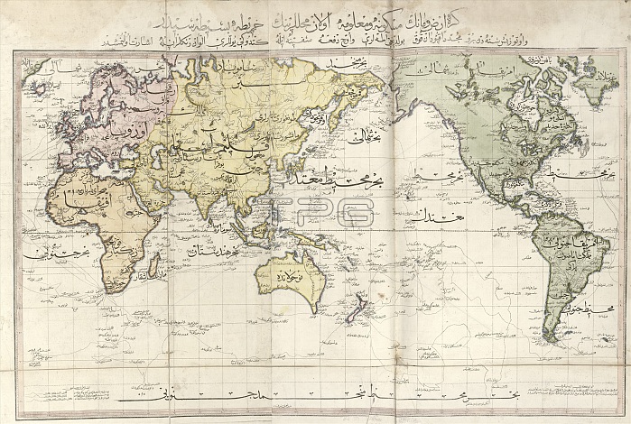
World map. Early 19th-century map of the world with labels in Ottoman Turkish. The colour scheme divides the world into four continents: Europe (pink), Africa (orange), Asia (yellow), and the Americas (green). This map is from 'Cedid atlas tercumesi' (1803), an atlas produced by Tab'hane-yi Humayun and published in Istanbul, Turkey, during the period of the Ottoman Empire. The maps were based on those made by British cartographer William Faden (1749-1836) for his General atlas.
| px | px | dpi | = | cm | x | cm | = | MB |
Details
Creative#:
TOP16235313
Source:
達志影像
Authorization Type:
RM
Release Information:
須由TPG 完整授權
Model Release:
N/A
Property Release:
N/A
Right to Privacy:
No
Same folder images:
1800s180319thcenturyafricaafricanamericasartworkasiaasianatlascartographycedidatlastercumesicolor-codedcolour-codedcontinentcontinentalcontinentscylindricalprojectiondiagrameartheuropeeuropeangeographicalgeographyglobalhistoricalhistoryillustrationlatinamericamapno-onenobodynorthamericanorthamericanottomanplanetplanetarypublicationsouthamericasouthamericantab'hane-yihumayunturkishwilliamfadenworldworldmapworldwide
1800s180319thafricaafricanamericaamericaamericaamericanamericanamericasartworkasiaasianatlasatlascartographycedidcenturycolor-codedcolour-codedcontinentcontinentalcontinentscylindricaldiagrameartheuropeeuropeanfadengeographicalgeographyglobalhistoricalhistoryhumayunillustrationlatinmapmapno-onenobodynorthnorthottomanplanetplanetaryprojectionpublicationsouthsouthtab'hane-yitercumesiturkishwilliamworldworldworldwide
 Loading