
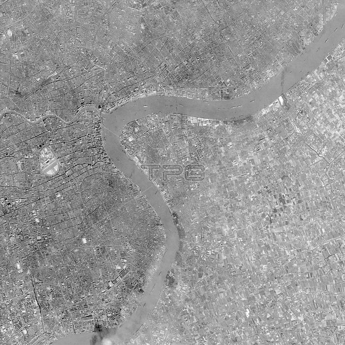
Shanghai, China, satellite photo 1968. The Huangpu River (upper right down to lower left) forms a border between the dense urban city (left) and rural farmland (left). See image C026/3110 for similar satellite viewpoint taken in 2015. The American Corona KH spy satellites captured images using black and white photographic roll film and panoramic cameras. A re-entry capsule containing the exposed film would be released and sent back to Earth for recovery. This image was taken on the 18th November 1968.
| px | px | dpi | = | cm | x | cm | = | MB |
Details
Creative#:
TOP16005260
Source:
達志影像
Authorization Type:
RM
Release Information:
須由TPG 完整授權
Model Release:
N/A
Property Release:
N/A
Right to Privacy:
No
Same folder images:
18/11/6818thnovember1960's196820thcenturyamericansecretserviceasiaasianblack-and-whitechinacitycoldwarcoronacovertearthobservationespionagehistoricalhistoryhuangpuriverintelligencekeyholekhkhsatellitemappingmilitarymonochromephotographicpudongreconnaissancerollfilmsatellitesatelliteimagesecretshanghaispaceflightspaceflightspycameraspysatellitesurveillanceunitedstatesusgovernmentusspyusa
18/11/6818th1960's196820thamericanasiaasianblack-and-whitecameracenturychinacitycoldcoronacovertearthespionagefilmflightgovernmenthistoricalhistoryholehuangpuimageintelligencekeykhkhmappingmilitarymonochromenovemberobservationphotographicpudongreconnaissanceriverrollsatellitesatellitesatellitesatellitesecretsecretserviceshanghaispacespaceflightspyspyspystatessurveillanceunitedusususawar
 Loading