
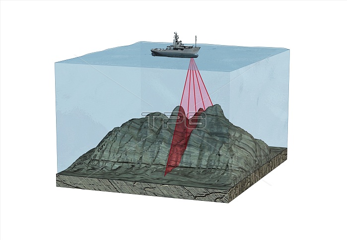
Mapping the ocean floor. Cutaway computer illustration of a ship using sonar beams (sound waves) to map the ocean floor. The sonar beams reflect off the ocean floor and are collected by a receiver. The time taken for the beam to return allows the depth of water to be calculated. Maps of the ocean floor can be used to study plate tectonics, model ocean currents, and map wildlife habitats, amongst other applications.
| px | px | dpi | = | cm | x | cm | = | MB |
Details
Creative#:
TOP15939337
Source:
達志影像
Authorization Type:
RM
Release Information:
須由TPG 完整授權
Model Release:
No
Property Release:
No
Right to Privacy:
No
Same folder images:
acousticacousticsartworkbathymetrybeambeamscutoutcutoutscut-awaycut-outcut-outscutawaycutoutcutoutsdeviceechosounderengineeringequipmentgeographicalgeographyillustrationmapmappingmultibeamsonaroceanflooroceanographyresearchresearchingseaseafloorseabedshipsonarsonarssoundwaveswathsweepsweepingtechnologicaltechnologyterraintopographictopographicalvehiclevesselwaveswhitebackground
acousticacousticsartworkbackgroundbathymetrybeambeamscutcutcut-awaycut-outcut-outscutawaycutoutcutoutsdeviceechosounderengineeringequipmentfloorfloorgeographicalgeographyillustrationmapmappingmultibeamoceanoceanographyoutoutsresearchresearchingseaseaseabedshipsonarsonarsonarssoundswathsweepsweepingtechnologicaltechnologyterraintopographictopographicalvehiclevesselwavewaveswhite
 Loading