
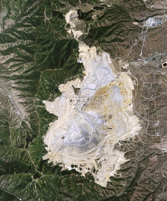
Bingham Canyon Mine landslide. Satellite image of Bingham Canyon Mine, Utah, USA, three weeks after the largest non-volcanic landslide in the history of North America. At 4 km wide and 1200 metres deep, the Bingham Canyon Mine is one of the largest open-pit mines in the world. During this event 65-70 million cubic metres of dirt and rock slid down the side of the pit. It was large enough that seismic earthquake recorders detected the rumble of sliding debris. Imaged by the Advanced Land Imager (ALI) on NASA's Earth Observing-1 (EO-1) satellite, on 2nd May 2013.
| px | px | dpi | = | cm | x | cm | = | MB |
Details
Creative#:
TOP14864964
Source:
達志影像
Authorization Type:
RM
Release Information:
須由TPG 完整授權
Model Release:
N/A
Property Release:
No
Right to Privacy:
No
Same folder images:
02/05/20132may201321stcentury2ndadvancedlandimageraliamericanbinghamcanyonmineearthobservationearthobserving-1environmentenvironmentalscienceeo-1fromspacegeographicalgeographygeologicalgeologyhistoricalhistorylandslidelandsliplargelargestminingno-onenobodynon-volcanicnorthamericaopen-pitminerockavalanchesatellitesatelliteimageunitedstatesususautah
02/05/20132201321st2ndadvancedaliamericaamericanavalanchebinghamcanyoncenturyearthearthenvironmentenvironmentaleo-1fromgeographicalgeographygeologicalgeologyhistoricalhistoryimageimagerlandlandslidelandsliplargelargestmayminemineminingno-onenobodynon-volcanicnorthobservationobserving-1open-pitrocksatellitesatellitesciencespacestatesunitedususautah
 Loading