
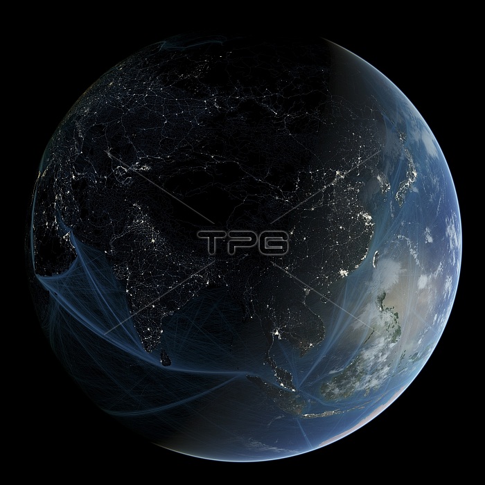
Asia at night. Map showing urban and industrial lights over Asia at night. It was created by combining data from NASA's Moderate Resolution Imaging Spectroradiometer (MODIS) aboard the Terra satellite. Most lights originate from artificial lighting in cities and towns. This image also shows shipping routes superimposed over the Atlantic and Pacific Oceans. Data acquired from NOAA's SEAS BBXX database, from 14.10.2004 to 15.10.2005.
| px | px | dpi | = | cm | x | cm | = | MB |
Details
Creative#:
TOP14563728
Source:
達志影像
Authorization Type:
RM
Release Information:
須由TPG 完整授權
Model Release:
N/A
Property Release:
No
Right to Privacy:
No
Same folder images:
21stcenturyanthropoceneartificiallightingartworkasiabiomassburningburmachinacitiescitycityatnightcitylightsearthearthatnightearthobservationgeographicalgeographyglobehumanimpacthumanpresenceillustrationindiaindonesiajapanlaoslightlightpollutionmalaysiamankindmoderateresolutionimagingmodernmodernitymodisnightlightsnighttimenight-lightplanetrussiasatellitesatelliteimageshippinglanesshippingroutesspectroradiometerthailandurbanisationurbanizationvietnamworldatnight
21stanthropoceneartificialartworkasiaatatatbiomassburmaburningcenturychinacitiescitycitycityearthearthearthgeographicalgeographyglobehumanhumanillustrationimageimagingimpactindiaindonesiajapanlaneslaoslightlightlightinglightslightsmalaysiamankindmoderatemodernmodernitymodisnightnightnightnightnightnight-lightobservationplanetpollutionpresenceresolutionroutesrussiasatellitesatelliteshippingshippingspectroradiometerthailandtimeurbanisationurbanizationvietnamworld
 Loading