
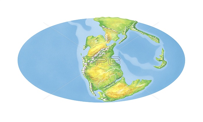
Triassic world map. Elliptical projection of the Earth's continents as they appeared during the Triassic Period (250 to 200 million years ago). At this time, the Earth's land masses formed a supercontinent called Pangea. This had formed around 300 million years ago and began to break up around 200 million years ago. The alignment of the continents shown here dates to around 220 million years ago, showing vast continental desert interiors. For the break up of Pangea and world maps for the Triassic, Jurassic and Cretaceous periods, see images C018/0196 to C018/0199.
| px | px | dpi | = | cm | x | cm | = | MB |
Details
Creative#:
TOP12443125
Source:
達志影像
Authorization Type:
RM
Release Information:
須由TPG 完整授權
Model Release:
No
Property Release:
No
Right to Privacy:
No
Same folder images:
EARTHPANGEAPLANETGLOBECONTINENTLANDSEASUPERCONTINENTGEOGRAPHYGEOLOGYPHYSICALGEOGRAPHYEARTHSCIENCEHISTORYPALAEONTOLOGYPALAEOGEOGRAPHYARTWORKILLUSTRATIONELLIPSEPREHISTORYTRIASSICGLOBALMAPELLIPTICALPROJECTIONWHITEBACKGROUNDCUTOUTSERIESSEQUENCECONTINENTALDRIFTPLATETECTONICSCONTINENTSPANGAEACUT-OUTCUTOUTCUT-OUTSCUTOUTSCUTOUTSGEOGRAPHICALGEOLOGICALHISTORICALPALEONTOLOGYPREHISTORIC
ARTWORKBACKGROUNDCONTINENTCONTINENTALCONTINENTSCUTCUTCUT-OUTCUT-OUTSCUTOUTCUTOUTSDRIFTEARTHEARTHELLIPSEELLIPTICALGEOGRAPHICALGEOGRAPHYGEOGRAPHYGEOLOGICALGEOLOGYGLOBALGLOBEHISTORICALHISTORYILLUSTRATIONLANDMAPOUTOUTSPALAEOGEOGRAPHYPALAEONTOLOGYPALEONTOLOGYPANGAEAPANGEAPHYSICALPLANETPLATEPREHISTORICPREHISTORYPROJECTIONSCIENCESEASEQUENCESERIESSUPERCONTINENTTECTONICSTRIASSICWHITE
 Loading