
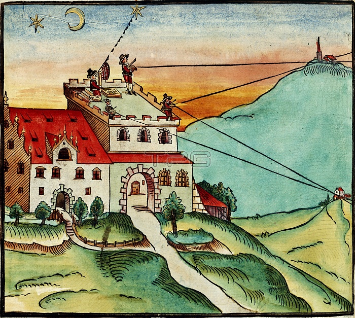
Surveying methods. 16th-century coloured woodcut showing the methods used by surveyors. Four men on the tower at left are using surveying equipment to measure the position of the stars and to take sightings of other landmarks in the surrounding area. Trigonometric analysis of the angles allows calculations of the distances and heights of the landmarks, allowing accurate maps to be drawn. This artwork is from 'Methodus Geometrica' (Nuremberg, 1598) by German cartographer Paul Pfinzing (1554-1599).
| px | px | dpi | = | cm | x | cm | = | MB |
Details
Creative#:
TOP11718942
Source:
達志影像
Authorization Type:
RM
Release Information:
須由TPG 完整授權
Model Release:
NO
Property Release:
NO
Right to Privacy:
No
Same folder images:
HUMANSEXTANTTHEODOLITEEQUIPMENTGERMANYEUROPEBUILDINGCASTLETOWERLANDMARKSURVEYINGMAPPINGSIGHTINGHISTORYGEOGRAPHYCARTOGRAPHYTECHNOLOGYSURVEYORMAPPERCARTOGRAPHERADULTMANMALECAUCASIANARTWORKILLUSTRATIONWOODCUT16THCENTURY1598LANDMARKSTOWERSHILLSHILLYHILLSTARSTARSMOONMETHODUSGEOMETRICAPAULPFINZINGTRIGONOMETRYTRIGONOMETRICANGLESDISTANCESPERSONPEOPLEEUROPEANHISTORICALGEOGRAPHICALTECHNOLOGICALWHITE1500SGERMAN
1500S159816THADULTANGLESARTWORKBUILDINGCARTOGRAPHERCARTOGRAPHYCASTLECAUCASIANCENTURYDISTANCESEQUIPMENTEUROPEEUROPEANGEOGRAPHICALGEOGRAPHYGEOMETRICAGERMANGERMANYHILLHILLSHILLYHISTORICALHISTORYHUMANILLUSTRATIONLANDMARKLANDMARKSMALEMANMAPPERMAPPINGMETHODUSMOONPAULPEOPLEPERSONPFINZINGSEXTANTSIGHTINGSTARSTARSSURVEYINGSURVEYORTECHNOLOGICALTECHNOLOGYTHEODOLITETOWERTOWERSTRIGONOMETRICTRIGONOMETRYWHITEWOODCUT
 Loading