
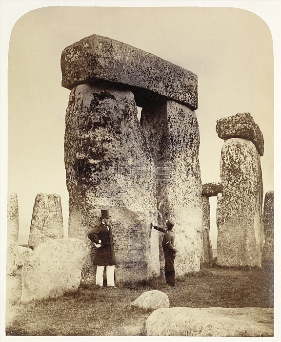
Stonehenge survey. Surveyors at Stonehenge in the 1860s. This view shows trilithons B and C, seen from the south-west. Stonehenge is a prehistoric circle of standing stones located in Wiltshire, UK. It dates from 3000 BC to 2000 BC, with different construction phases in that period. Theories about its function range from astronomical observatory to religious site. This photograph is from 'Plans and Photographs of Stonehenge, and of Turusachan in the Island of Lewis' (1867). The photographs were taken by the Ordnance Survey Department, led by Sir Henry James (at left, 1803-1877).
| px | px | dpi | = | cm | x | cm | = | MB |
Details
Creative#:
TOP11718936
Source:
達志影像
Authorization Type:
RM
Release Information:
須由TPG 完整授權
Model Release:
NO
Property Release:
NO
Right to Privacy:
No
Same folder images:
HENRYJAMESMEGALITHSTONECIRCLEHUMANWILTSHIREENGLANDSTONEHENGEUKBRITAINEUROPESURVEYINGHISTORYARCHAEOLOGYSURVEYORMAPPERCARTOGRAPHERVISITORADULTMANMALECAUCASIANMONOCHROMEBLACK-AND-WHITE19THCENTURY1867PREHISTORYNEOLITHICSTONEAGEUNITEDKINGDOMTRILITHONTRILITHONSTRILITHONBTRILITHONCSTANDINGSTONESSTANDINGSTONEPLANSANDPHOTOGRAPHSOFORDNANCESURVEYDEPARTMENTSURVEYORSMAPPERSCARTOGRAPHERSVISITORSMENUNIFORMDIRECTORHISTORICALPERSONPEOPLEENGLISHBRITISHEUROPEANARCHAEOLOGICALARCHEOLOGY1800SPREHISTORIC
1800S186719THADULTAGEANDARCHAEOLOGICALARCHAEOLOGYARCHEOLOGYBBLACK-AND-WHITEBRITAINBRITISHCCARTOGRAPHERCARTOGRAPHERSCAUCASIANCENTURYCIRCLEDEPARTMENTDIRECTORENGLANDENGLISHEUROPEEUROPEANHENRYHISTORICALHISTORYHUMANJAMESKINGDOMMALEMANMAPPERMAPPERSMEGALITHMENMONOCHROMENEOLITHICOFORDNANCEPEOPLEPERSONPHOTOGRAPHSPLANSPREHISTORICPREHISTORYSTANDINGSTANDINGSTONESTONESTONESTONEHENGESTONESSURVEYSURVEYINGSURVEYORSURVEYORSTRILITHONTRILITHONTRILITHONTRILITHONSUKUNIFORMUNITEDVISITORVISITORSWILTSHIRE
 Loading