
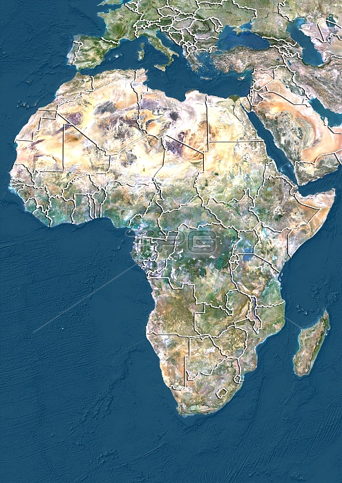
Africa. North is at top. Satellite image of Africa, southern Europe and part of the Middle East, showing the borders (white lines) of the countries. The Mediterranean Sea, (blue, upper centre), Atlantic Ocean (blue, left) and Indian Ocean (blue, lower right) are also shown. Image compiled from data acquired by LANDSAT satellites, in 2012.
| px | px | dpi | = | cm | x | cm | = | MB |
Details
Creative#:
TOP10392514
Source:
達志影像
Authorization Type:
RM
Release Information:
須由TPG 完整授權
Model Release:
No
Property Release:
No
Right to Privacy:
No
Same folder images:
201221STCENTURYBIRDSEYEVIEWBIRDS-EYEVIEWBORDERBORDERSBOUNDARIESBOUNDARYCARTOGRAPHYCOUNTRIESCOUNTRYEARTHOBSERVATIONENVIRONMENTENVIRONMENTALFROMABOVEFRONTIERFRONTIERSGEOGRAPHICALGEOGRAPHYLANDMAPNATIONNATIONSELEVATIONELEVATIONSINDIANOCEANATLANTICOCEANOCEANSCONTINENTCONTINENTSTOPOGRAPHICTOPOGRAPHYMEDITERRANEANSEAEUROPEMIDDLEEASTARABIANPENINSULAAFRICASATELLITESATELLITEIMAGEFROMSPACEMADAGASCARLANDSAT
201221STABOVEAFRICAARABIANATLANTICBIRDSBIRDS-EYEBORDERBORDERSBOUNDARIESBOUNDARYCARTOGRAPHYCENTURYCONTINENTCONTINENTSCOUNTRIESCOUNTRYEARTHEASTELEVATIONELEVATIONSENVIRONMENTENVIRONMENTALEUROPEEYEFROMFROMFRONTIERFRONTIERSGEOGRAPHICALGEOGRAPHYIMAGEINDIANLANDLANDSATMADAGASCARMAPMEDITERRANEANMIDDLENATIONNATIONSOBSERVATIONOCEANOCEANOCEANSPENINSULASATELLITESATELLITESEASPACETOPOGRAPHICTOPOGRAPHYVIEWVIEW
 Loading