
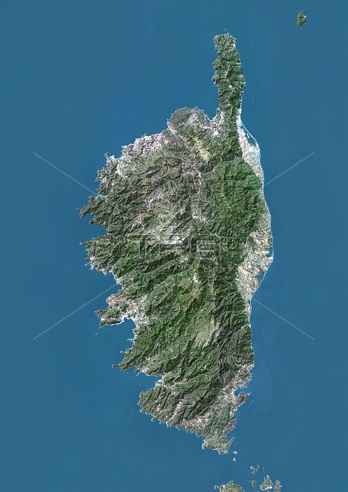
Corsica, France. North is at top. Natural colour satellite image showing the French island of Corsica, in the Mediterranean Sea (blue). Corsica is split into two departments, Haute-Corse and Corse-du-Sud. It lies southeast of the French mainland, west of Italy, and north of the Italian island of Sardinia. Image compiled from data acquired by LANDSAT satellites, in 2012.
| px | px | dpi | = | cm | x | cm | = | MB |
Details
Creative#:
TOP10392500
Source:
達志影像
Authorization Type:
RM
Release Information:
須由TPG 完整授權
Model Release:
No
Property Release:
No
Right to Privacy:
No
Same folder images:
201221STCENTURYBIRDSEYEVIEWBIRDS-EYEVIEWCARTOGRAPHYCOUNTRIESCOUNTRYEARTHOBSERVATIONENVIRONMENTENVIRONMENTALFROMABOVEFROMSPACEFRONTIERFRONTIERSGEOGRAPHICALGEOGRAPHYLANDLANDSATMAPNATIONNATURALCOLOURNATUREREGIONSATELLITESATELLITEIMAGETOPOGRAPHICTOPOGRAPHYWESTERNEUROPEEUROPEEUROPEANFRANCEFRENCHISLANDCORSICAMEDITERRANEANSEAWATERHAUTE-CORSECORSE-DU-SUD
201221STABOVEBIRDSBIRDS-EYECARTOGRAPHYCENTURYCOLOURCORSE-DU-SUDCORSICACOUNTRIESCOUNTRYEARTHENVIRONMENTENVIRONMENTALEUROPEEUROPEEUROPEANEYEFRANCEFRENCHFROMFROMFRONTIERFRONTIERSGEOGRAPHICALGEOGRAPHYHAUTE-CORSEIMAGEISLANDLANDLANDSATMAPMEDITERRANEANNATIONNATURALNATUREOBSERVATIONREGIONSATELLITESATELLITESEASPACETOPOGRAPHICTOPOGRAPHYVIEWVIEWWATERWESTERN
 Loading