
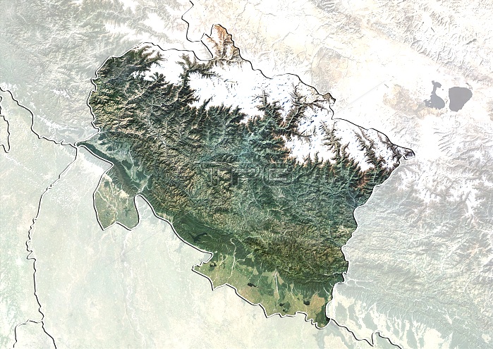
Uttarakhand, India. North is at top. Natural colour satellite image showing the state of Uttarakhand, India, with the surrounding states shaded out. India is located in South Asia. Uttarakhand borders the Tibet Autonomous Region to the north, the Mahakali Zone of the Far-Western Region, Nepal to the east, and the Indian states of Uttar Pradesh to the south and Himachal Pradesh to the northwest. Image compiled from data acquired by the LANDSAT 5 and 7 satellites, in 2000. Images highlighting all other regions of this country are available. For further information please contact SPL.
| px | px | dpi | = | cm | x | cm | = | MB |
Details
Creative#:
TOP10277444
Source:
達志影像
Authorization Type:
RM
Release Information:
須由TPG 完整授權
Model Release:
NO
Property Release:
NO
Right to Privacy:
No
Same folder images:
200021STCENTURYASIAASIANBIRDSEYEVIEWBIRDS-EYEVIEWBORDERBORDERSBOUNDARIESBOUNDARYCARTOGRAPHYCOUNTRIESCOUNTRYEARTHOBSERVATIONENVIRONMENTENVIRONMENTALFROMABOVEFROMSPACEFRONTIERFRONTIERSGEOGRAPHICALGEOGRAPHYINDIALANDLANDSAT5LANDSAT7MAPMASKEDNATIONNATURALCOLOURNATURESATELLITESATELLITEIMAGESOUTHASIASTATESTATESTOPOGRAPHICTOPOGRAPHYWATERSTATEUTTARAKHANDUTTARANCHAL
57200021STABOVEASIAASIAASIANBIRDSBIRDS-EYEBORDERBORDERSBOUNDARIESBOUNDARYCARTOGRAPHYCENTURYCOLOURCOUNTRIESCOUNTRYEARTHENVIRONMENTENVIRONMENTALEYEFROMFROMFRONTIERFRONTIERSGEOGRAPHICALGEOGRAPHYIMAGEINDIALANDLANDSATLANDSATMAPMASKEDNATIONNATURALNATUREOBSERVATIONSATELLITESATELLITESOUTHSPACESTATESTATESTATESTOPOGRAPHICTOPOGRAPHYUTTARAKHANDUTTARANCHALVIEWVIEWWATER
 Loading