
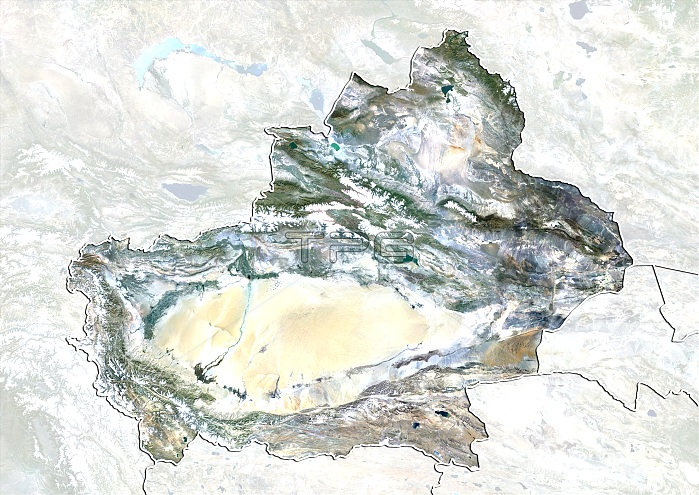
Xinjiang, China. North is at top. Natural colour satellite image showing the Xinjiang region of China, with the surrounding Chinese provinces and regions shaded out. Image compiled from data acquired by the LANDSAT 5 and 7 satellites, in 2000. Images highlighting all other regions of this country are available. For further information please contact SPL.
| px | px | dpi | = | cm | x | cm | = | MB |
Details
Creative#:
TOP10277440
Source:
達志影像
Authorization Type:
RM
Release Information:
須由TPG 完整授權
Model Release:
NO
Property Release:
NO
Right to Privacy:
No
Same folder images:
200021STCENTURYASIABIRDSEYEVIEWBIRDS-EYEVIEWBORDERBORDERSBOUNDARIESBOUNDARYCARTOGRAPHYCHINACHINESECOUNTRIESCOUNTRYEARTHOBSERVATIONENVIRONMENTENVIRONMENTALFROMABOVEFROMSPACEFRONTIERFRONTIERSGEOGRAPHICALGEOGRAPHYLANDLANDSAT5LANDSAT7MAPMASKEDNATIONNATURALCOLOURNATUREPROVINCEPROVINCESREGIONSSATELLITESATELLITEIMAGESTATEXINJIANGREGIONTOPOGRAPHICTOPOGRAPHY
57200021STABOVEASIABIRDSBIRDS-EYEBORDERBORDERSBOUNDARIESBOUNDARYCARTOGRAPHYCENTURYCHINACHINESECOLOURCOUNTRIESCOUNTRYEARTHENVIRONMENTENVIRONMENTALEYEFROMFROMFRONTIERFRONTIERSGEOGRAPHICALGEOGRAPHYIMAGELANDLANDSATLANDSATMAPMASKEDNATIONNATURALNATUREOBSERVATIONPROVINCEPROVINCESREGIONREGIONSSATELLITESATELLITESPACESTATETOPOGRAPHICTOPOGRAPHYVIEWVIEWXINJIANG
 Loading