
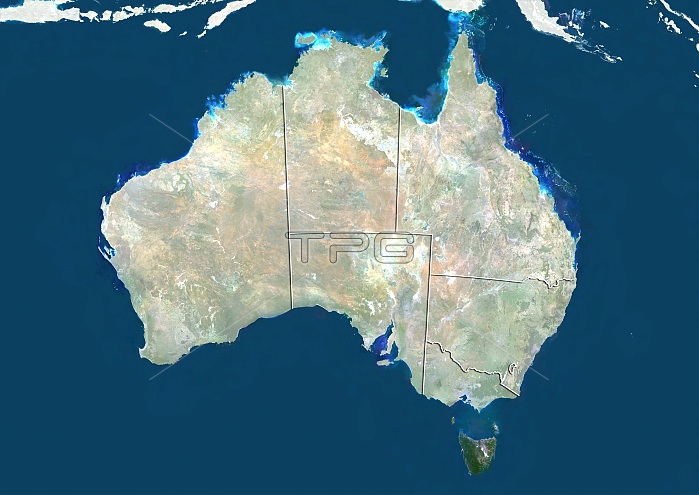
Australia. Satellite image showing Australia divided into its regions. Australia comprises six states: New South Wales, Queensland, South Australia, Tasmania (island, lower right), Victoria, and Western Australia; and two major mainland territories: the Northern Territory and the Australian Capital Territory. Image compiled from data acquired by the LANDSAT 5 and 7 satellites, in 2000. Images highlighting all other regions of this country are available. For further information please contact SPL.
| px | px | dpi | = | cm | x | cm | = | MB |
Details
Creative#:
TOP10277428
Source:
達志影像
Authorization Type:
RM
Release Information:
須由TPG 完整授權
Model Release:
NO
Property Release:
NO
Right to Privacy:
No
Same folder images:
200021STCENTURYAUSTRALIAAUSTRALIANAUSTRALIANCAPITALTERRITORYBASSSTRAITBIRDSEYEVIEWBIRDS-EYEVIEWCARTOGRAPHYCLOUDLESSCONTINENTCOUNTRYDOWNUNDEREARTHOBSERVATIONENVIRONMENTENVIRONMENTALFROMABOVEFROMSPACEGEOGRAPHICALGEOGRAPHYINDIANOCEANISLANDSLANDLANDSAT5LANDSAT7MAPNATURALCOLOURNATURENEWSOUTHWALESNORTHERNTERRITORYPACIFICOCEANQUEENSLANDSATELLITESATELLITEIMAGESOUTHAUSTRALIASOUTHERNHEMISPHERESTATESTATESTASMANIATASMANIANTERRITORIESTOPOGRAPHICTOPOGRAPHYVICTORIAWESTERNAUSTRALIA
21ST572000ABOVEAUSTRALIAAUSTRALIAAUSTRALIAAUSTRALIANAUSTRALIANBASSBIRDSBIRDS-EYECAPITALCARTOGRAPHYCENTURYCLOUDLESSCOLOURCONTINENTCOUNTRYDOWNEARTHENVIRONMENTENVIRONMENTALEYEFROMFROMGEOGRAPHICALGEOGRAPHYHEMISPHEREIMAGEINDIANISLANDSLANDLANDSATLANDSATMAPNATURALNATURENEWNORTHERNOBSERVATIONOCEANOCEANPACIFICQUEENSLANDSATELLITESATELLITESOUTHSOUTHSOUTHERNSPACESTATESTATESSTRAITTASMANIATASMANIANTERRITORIESTERRITORYTERRITORYTOPOGRAPHICTOPOGRAPHYUNDERVICTORIAVIEWVIEWWALESWESTERN
 Loading